Category Archives: HIking in Iceland

ICELAND 2016 6. SKJALDBREIÐUR

I have wanted to hike up Skjaldbreiður for most of the decade I have been visiting Iceland. Its name means broad shield and it is the prototype of a shield volcano. It sits on the horizon each time I visit the historic Thingvellir National Park, reminding me of my first attempt to reach its summit in 2010. I came to Iceland in early September that year, later than usual. Late August had always seemed to have reasonable weather, so why not September? But that year the weather gods (most likely Thor) did not cooperate. The skies were usually cloudy, and temps cooler than expected. Bragi and I tried a hike up Snæfellsjökull, a big glaciated mountain northwest of Reykjavik, but the sno-cat tracks we planned to follow were buried in early season snow, the possibility of crevasses lay beneath that light layer, and clouds kept drifting across our landscape, making navigation a continual challenge. We enjoyed early progress up the mountain, but decided not to risk our safety in the chancy conditions and returned downhill after hiking a couple miles.

We were scheduled to hike Skjaldbreiður the next day of that tour in 2010, but the weather started misty and only got worse as we approached the mountain. I recognized the driving route as far as the turn from northbound Highway 1 toward Thingvellir on Route 36. When the road to the Thingvellir National Park headed east, we drove north on two lane Highway 52. As the road started gaining elevation the mist turned to rain and then snow. Then the wind rose and it really did not look like a good day for a hike up a tree-less volcanic mountain. Bragi did not like disappointing me two days in a row, and drove as far toward the trailhead as he could. I was ready to turn around as soon as the snow started, but he wanted to make sure it was not just a brief shower. Later we learned that we had experienced the start of a severe and totally unexpected early-season blizzard. Many farmers had left their animals out in the weather, and a lot of sheep were lost in the several feet of snow that fell in the highlands and remote rural areas.

I think I had put Skjaldbreiður on itineraries a few times during the years in between, but either the weather or the schedule had not worked out. I was hopeful this year, but not totally optimistic. I had looked at an Icelandic hiking guidebook (Ari Trausti Guðmundsson’s Íslensk fjöll : gönguleiðir á 151 tind) before this year′s trip. It describes the hike as longer with more elevation gain than I had expected: 9 miles distance round-trip and almost 2000 feet to climb. The one good change since the last time I had planned to hike the peak was that jeeps and motorbikes were no longer allowed to join hikers on the ascent. Conservationists had won the battle to save this and some other scenic peaks from motorized mountain climbs.

The weather on the day we picked to hike up Skjaldbreiður this year did not look promising. We left Reykjavik in mist that was thick enough to require windshield wipers to clear our view. I recognized the gravel road on the west side of Skjaldbreiður as soon as we left the pavement and wondered if the weather would chase us from its approach yet again. When we turned onto the road on the north side of the mountain, the rain lightened. When Bragi parked the car at the trailhead, the rain stopped. We climbed out, put on our boots, and the weather held. Perhaps we would be successful!

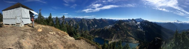
Bragi had told us there is a big crater full of snow just under the summit ridge. As we started hiking up the trackless north slope, large snowfields appeared below the rocky top. It didn´t seem far away, but I could not tell whether the snow we saw was in a basin like a crater, or was just a sloping mountainside covered in white.

As we ascended, our views of the surrounding landscape grew around us. First we could only see rocky ridges across the narrow valley of our immediate vicinity. As we reached the snowfields on the upper slopes we started to see the large glacier fields of Langjökull farther north. I was surprised how quickly we climbed the mountain with no

20160801_141737

Langjokull’s glacier fields on the distant ridges

trail. It certainly did not seem as far or as steep as the guidebook suggested. For some reason my boots did not give me as good traction on the snow as Bragi and Susan had. So I took a slightly longer route on the rocky edge of the snowfield. While not smooth, the surface underfoot was not too lumpy, so I was able to keep up with my companions′ pace and followed a parallel route up the mountain.

I caught up as they started to climb the short rocky traverse to the ridge top. It was no more than a twenty-foot ascent on rocks that seemed piled like stairs. There were also flat rocks on the ridge available for sitting and enjoying the view of the snow-filled crater20160801_133043

Looking down into the crater

and its black perimeter, and a climb of a few more feet to the highest point on the north side. Almost as soon as we sat down to enjoy the views and our lunches, Bragi´s phone rang and we heard him tell someone where we were and how clear our view was. ‘‘Rain? No, we have none of that here.” We were surprised to learn that we were apparently at one of the few spots in Iceland without rain that day.

My GPS reported we had hiked three miles and gained only 1000 feet on our way to the top. Bragi had certainly found an easy route for us. He said it was the usual way for local hikers, but it is clear that a symmetrical mountain, which a shield volcano must be, may well offer a variety of access paths. We thoroughly enjoyed ours.

On the way down we paid more attention to the late summer vegetation on the20160801_153423 slope: bladder campion, mosses, and a variety of grasses. We also noticed wonderful patterns in the undisturbed lava. And we observed dark clouds headed in our direction again. Finally the car came into view and we began to wonder if we would reach the car first. We succeeded, but not by much. We jumped inside and changed out of our hiking boots as the rain began its tattoo on the roof.p1030086

Our lodging that night was at the Efri-Sel Hostel, quite close to a similarly named golf course and just outside the town of Fluðir. The golf traffic supports an associated cafe, and we joined the family-dominated crowd there for burgers.

The hostel is a very comfortable modern house on a farm property, providing a kitchen, dining and lounge area laid out to encourage guests to join in general conversation and get acquainted with other visitors. We enjoyed meeting international couples from Germany and Ireland, South Africa and Taiwan, and England. Other assets of the house are laundry machines and a roomy hot tub –both of which we enjoyed using.

ICELAND 2016 5. Hiking at Ulfljótsvatn, Nesjavellir and Visiting Thingvellir

This was intended to be a recovery day after a big hike. But yesterday’s full day hike had turned into a moderate afternoon hike, so we had lots of energy for exploring the area near the Ljosafoss Skóli Hostel. Susan and I had noticed a nearby lake on our map that appeared to have a shoreline trail. Bragi remembered a gravel road that led to the trail, so off we went—with his warning that it might a buggy hike beside the water.

We parked at the top of a steep hill, and headed down to Ulfljótsvatn. Despite the homes sitting beside the road approaching the pretty blue lake, there were no boats on the surface or walkers on the shoreline. Once we reached level ground, all the houses were out of sight and we had the place to ourselves.20160731_032402The trails became less developed the farther we went. It seemed they were used mostly by sheep and occasional birdwatchers. We saw swans on the water, heard and finally spotted a pair of loons. Among the grasses we observed pipits and wagtails, too. Occasionally we walked through a cloud of midges, but the bugs were cooperatively stationary, so they did not bother us much at all.

After cautiously crossing a marshy area and climbing over a small grassy hill, we were surprised to find some low stone walls and an archway, remains of a small building abandoned in the pastoral scenery above the lake. After snapping some photos and ascending one more hill, we wandered back through the tall grasses and returned up the road to the car.


Walking through the unknown countryside somehow made me think of the very first hike I had taken in Iceland, way back in 2007. The tour I was with had stayed in a grim workers´ hostel (small dark rooms and bathrooms, narrow halls, no fresh vegetables; I can’t remember how else it offended us) and hiked from its door into a geothermal wonderland. The lodging was close to the Nesjavellir Geothermal Powerplant, and it was surrounded by well-marked trails showing off the hot streams and colorful sulfurous soil that are features of the geologically-active area.

Before starting the hike, we visited a new hotel that has opened close to the site of the old hostel. The Hotel Ion is intended for international visitors who fly in for exclusive tours of Iceland’s highlights. I was a little surprised at the courtesy with which they welcomed three almost random hikers, but happy to take a coffee break in such elegant surroundings.20160731_064758

We drove a short distance to leave our car beside an adventure park that features a complex climbing structure with physical challenges for agile children and adults. We had a different adventure in mind. For the next couple hours we hiked past steamy streams, bore hole enclosures, neon green moss, carefully crossed narrow rocky creeks, and took in the views from wooden streamside platforms. After we had seen the highlights, Bragi returned for the car while Susan and I continued to a hilltop viewpoint beside a roadway. Our route didn’t always follow the developed trails, so we surprised pairs of grazing sheep more than once.

20160731_073307

From there we drove to nearby Thingvellir (Þingvellir in Icelandic), a UNESCO World Heritage Site, as well as Icelandic National Park, both designations in recognition of its being the site of the world’s first parliament (Thing or Þing in Icelandic). About sixty years after the Vikings first settled in Iceland, the clans acknowledged they needed to get together to discuss and agree to laws they could live by. The clan representatives were appointed, not elected, and they were not able to record their decisions on paper, but these do not diminish their achievement. The representatives gathered from all over Iceland each summer, starting in 930. They camped under high cliffs that helped project the sound of speakers’ voices. They sat in council with their advisors and adopted laws, settled disputes and passed judgment on evil-doers.

016-imgp0887

We were lucky to visit Thingvellir late in the afternoon after the biggest crowds had gone. It was a fine ending to our patchwork day that was far more enjoyable than anticipated.

ICELAND 2016 4. Kirkjubæjarklaustur to Reynisfjara, Skógarfoss trail and Eyjafjallajökull Visitors Center.

Fimmvörðuháls is a high pass between Eyjafjallajökull and Mýrdalsjökull and the place where the first of the spring 2010 eruptions occurred that were identified with the Eyjafjallajökull volcano. You may remember all the air flights between Europe and the US and the rest of the world that were canceled that spring. Well, it all started on top of a very popular hiking route that starts (or ends) near Highway 1 at Skógarfoss.

The trail has been rerouted and this was the day I planned to hike as much of the trail to Fimmvörðuháls as we could. We were not planning to be back on the south coast again during the trip, so this was the only day available. I think I had been told it would be 14 or 15 miles roundtrip, and I was sure that some of the knees in the party would not be up for that distance, but I hoped we could do most of it.

As soon as we were in the car Bragi pointed out that we would drive right past Reynisfjara 1800811-r3-052-24a
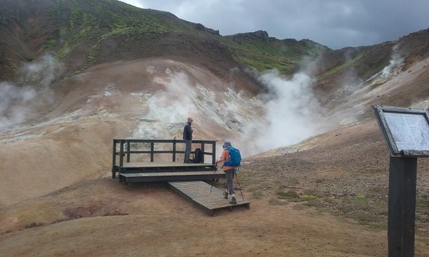
the black sand beach with columnar basalt cliffs and cave, beautiful sea stacks just offshore, and the strong possibility of sighting puffins. There was no way I could ignore the opportunity for Susan to visit this classic site. My hopes of spending a full day hiking toward Fimmvörðuháls were dashed, but I had a responsibility to introduce Iceland′s highlights to my companion, too.


I made an effort to be the gracious host, rather than the disappointed friend. And there were some features of Reynisfjara that day I have to admit were special. There were many i0016amore puffins flying to and from the tops of the beach′s dark basalt cliffs that day than I have ever seen before. These little birds are very colorful, diligent fisher-birds and energetic flappers of their short wide wings. They dig burrows in the cliff-top soil, lay eggs and tend their chicks in the little tunnels. They seem to make constant flights from the nests to the sea, returning with mouthfuls of little fish for their offspring.

I did not remember having seen the graceful cave formed in the cliff with basalt column walls during previous visits. It has apparently become a popular spot for wedding ceremonies, which is easy to understand. It not only provides shelter from rain and wind, it has great views of the sea and the sea stacks just down the beach.

When we arrived we noticed a new modern building beside the parking lot and the cliffs. Its big windows revealed an attractive café, but it did not open until late in the morning. Considering the big summer crowd, we thought they were missing a good bet. A nice cup of coffee would have been great about then, too. We returned to the café after our visit to the beach and discovered that the business had been funded by the local economic development group, called Katla Geopark, and by the European Union. We thought the latter investment interesting, as Iceland has not decided yet whether to join the Union.

We finally reached Skógarfoss  in the early afternoon and hiked for several hours. Skógarfoss is one of the beautiful waterfalls visible from Highway 1, and a popular tourist imgp2028attraction in its own right. For us the draw was the long set of metal and wooden steps that climb the 201-foot cliff beside the waterfall. The trail starts just east of the top of the falls, and follows the Skóga River upstream for most of the distance to Fimmvörðuháls.

From the top of the big falls we could easily see out to the ocean, as well as onto the glaciers in the distance. In our immediate vicinity was an open landscape of gentle hills and a rushing river. The trail led us gently uphill beside the river. It was not steep, but we kept passing waterfalls and cascades rushing toward the cliff and the vertical descent to the coastal plain.

20160730_062852The three of us agreed on a turn-around time and I left my companions behind as I tried to make the most distance in the little time we had. I finally stopped beside a beautiful stretch of riverbank with a large patch of cotton grass blossoms nodding in the breeze. I had hoped to reach the next ridge, but it was clearly farther than I anticipated. At that point Bragi shared that there is a landmark bridge that is a good destination on this trail. ‟Beyond that,” he said, ‟you reach the highlands and the views are not as interesting.” Maybe I will try to get here again and camp at the foot of Skógarfoss to assure a full day reserved for hiking to Fimmvörðuháls —or at least to the bridge.

We stopped at the small but interesting Eyjafjallajökull Visitor Center on our way south. I had previously enjoyed their 20-minute film about the nearby farm family’s experience with the 2010 eruption, and thought Susan would appreciate it too. I was surprised to see that the film I had admired had been replaced with one that may be considered a more polished production, but doesn’t seem as intimate an experience of the volcanic eruption. I was also irritated that Eyjafjallajökull was repeatedly referred to as “the glacier,” as if it were a glacier that had erupted, and not the volcano that has no other name.

From there we drove to our lodging for the next two nights, Ljosafoss Skoli Hostel. I had read for years that public boarding schools were used for tourist lodgings before there were many rural hotels in Iceland, but I had not stayed in one before. We had a reservation for a room with bunkbeds, shared bathroom and breakfast. What we found was a well-maintained, airy, three-story building with a large dining room and self-service kitchen at one end and a wide variety of sleeping rooms and lounges at the other end. Each floor had at least a lavatory, some restrooms also had showers and there was also a large shower room near the dining/kitchen area. The school buildings are now owned by a religious broadcasting company, which uses the hostel revenues to help fund their programs.

The room, building layout, staff and breakfast buffet all contributed to a comfortable stay. The kitchen seemed designed for a small staff, rather than several couples or pairs of people wandering around trying to figure out how to prepare their meals with unfamiliar appliances. Everyone seemed to recognize that this was part of the hostel experience; we all shared the space and information on how to make the kitchen work, and no one went away hungry.

It being day four in Iceland, it was time for me to do a little laundry. Out came my tightly capped small bottle of liquid laundry detergent and my bag of dirty quick-dry clothes. The clothes were swished in a shower room sink for a few minutes, rinsed in clean water, and rolled in a dry abandoned bath towel. (Bath towels are used after the shower, so they can’t be dirty, right?) Lay the clean wet clothes in the towel, roll up the towel, twist, unroll and remove your virtually spun-dry clothes. Return them to your room and hang them on a plastic line with tiny clothes pins, hang them on clothes hangers if available, or drape your clothes wherever they don’t irritate your roommate. By morning they should be mostly dry. Heavy hiking socks are the reliable exception, of course.

ICELAND 2016 3: Hvolsvöllur to Kirkjubæjarklaustur via Skaftafell, Jökulsárlón


Our principal destination for the day was a visit to western Europe’s largest national park, about 140 miles east of our starting point, Hvolsvöllur. We were headed for Skaftafell,  the oldest national park in the country, now included in the vast Vatnajökull National Park.  (A fell is a mountain or hill, while a jökull is a glacier.) Along the way we passed lots of small waterfalls descending from the coastal ridge and admired the moss that thickly carpets roadside lava fields when we stopped to stretch our legs. The vast glaciers that provide the soil and water for the coastal plains came into view in this stretch of the coast, building anticipation of the vast icy slopes at Skaftafell.

imgp1668 The Skaftafell park center is located at the foot of hills between two big glaciers, Skeiðarárjökull and Skaftafellsjökull. It has a very nice visitors center with displays explaining the geology and human history of the area, as well as artifacts from early research trips on the glaciers. Commercial guide companies have reception centers in small buildings along the edge of the visitors’ center’s parking lot. There is still no entrance fee to the park, so the lot is pretty full most summer days. There is also a campground without a separate entrance just past the parking lot, adding to the traffic.

Our plan was to do a moderate hike in the park. I expected some discussion of whether we should check out the visitor center first, but we set out for the trailhead as soon as we had 20160729_061719our daypacks ready to go. Our destination was Svartifoss (black waterfall) that appears on many postcards and tourist snapshots. I have often visited it on the way to farther destinations in the park, but this was our first real hike of the trip. We wanted to see how everyone’s knees felt about going up and down Icelandic trails and we knew there would be a lot of people on the trail.

We hiked a three-mile loop that felt like more, with lots of photo stops and brief interactions with other hikers from many countries on the trail. I remember hearing Icelandic, Spanish, Italian and British English; I am sure there were Asian and Indian visitors as well.

We ate lunch somewhere along the way and returned to the car in early afternoon. Bragi suggested we really should visit Jökulsárlón or Glacial Lagoon, as it is not much farther east (35 miles) along Highway 1. It is another very popular tourist stop, with duckboats doing tours among the icebergs calving from the glacier. We agreed to skip the boat tour and walk both the beach below the bridge and the shoreline beside the Lagoon. In August of 2016 the icebergs seemed about half the size of those in my photos a decade earlier. I realized that Susan didn’t have this comparison, so I did not mention my disappointment. I hoped the shrinkage reflected this summer’s warm temperatures, and not the general trend of quickly shrinking glaciers caused by climate change.

20160729_091222

We enjoyed walking the dark beach and looking at the chunks of ice glistening on the sand as they shrank. There were many fantastic shapes, and many photographers trying to capture the perfect image for their recorded memories.

The bridge at the mouth of the lagoon was built with concern for the possible effect of an iceberg the size of an apartment building ramming the structure. Fortunately, a clever engineer designed an iceberg trap that sits on the floor at the mouth of the lagoon, about fifty feet upstream from the bridge. I picture it as a broad bar with strong metal teeth extending toward the surface of the water. Nine-tenths of each iceberg is underwater (remember from grade school science class?) so icebergs that won’t fit under the bridge are stopped until they shrink down to a size that slides easily under the valued structure.

We walked beside the lagoon as well, taking photos there, too. We ended our visit there trying to skip stones that were rarely flat across the still lagoon waters, and then attempting to flip a floating chunk of ice by tossing rocks to shift its balance. I think the nine-tenths-below-the-water rule spelled failure from the start, but it was a nice day and we may have been reluctant to climb back into the car.

It was 77 miles back to our lodging at a farm hostel near Kirkjubæjarklaustur,  but we enjoyed the very green scenery, once we had passed the large glaciers and their gray outwash plains. Susan walked from the highway junction near the village to the pretty local waterfall, Stjornafoss, and an interesting local landmark known as Kirkjugólf, the Church Floor. The twenty-five by thirty-foot Floor is composed of the tops of a small field of basalt columns.

This little village is one of my favorite stops on the south coast of Iceland. But I have to admit that pronouncing Kirkjubæjarklaustur was a big challenge for me when I first visited here. After I had picked up a little vocabulary it was easier. Kirkju = church, bæjar = farm, klaustur = monastery/convent. Any word this long in a Germanic language is going to be a composite, so the challenge is to split the long word into manageable short ones. Figuring out where each syllable ends is a longer term issue.

No one has ever called me a foodie, but I have to admit that good food is one of the attractions of this area. I have stayed at least twice at Geirland, a really nice farm inn, a couple kilometers inland from the village. They serve excellent meals, but were not in our budget this trip. Once I had my Icelandic phone working (it took the second day in Iceland to get the battery charged, new phone company directions correctly interpreted, etc.), I phoned Geirland to see if they might have room for us in the dining room this evening. ‘No, they had a big tour group coming in, they were sorry but they had no room for us at the table.’

My next choice was the Systrakaffi,  a casual café near the highway junction where I had enjoyed lunches and late afternoon teas in the past. It was seven by the time we got there and there was a crowd at the door. We asked the people ahead of us and they said it seemed like a long wait for a menu that was shrinking with the evening’s food supply. We thought about returning to our hostel and pulling out one of our freeze-dried meals. Someone in the parking lot suggested another café — actually a deli they said, down the local road a bit farther. I don’t know that Kaffi Munkar  had been there the last time I visited the area, but they featured the excellent local farmed fish, bleikja or arctic char. I don’t eat farmed fish at home; there are lots of nice healthy wild fish available here. In Iceland I try out what is on the menu and have found bleikja delicious and affordable. Susan chose something more familiar to her and we both enjoyed our meals.

Our farm hostel lodging turned out to be another double bed in an even smaller room than our lodging the previous night. This hostel did have two bathrooms for the five rooms of guests, and beautiful farm scenery on the (ten mile?) country road from the highway. I slept well in the quiet surroundings. I think it was overpriced and cannot make any recommendations for budget lodging in this area.

At the end of the day I recorded the birds we had seen so far: whimbrel, great skua, arctic skua, arctic tern, fulmar, red wing, wagtail, whooper swan, plover, snipe, oyster catcher. It has taken a while for me to become familiar with these north Atlantic birds, but birds are most of the wildlife to be seen in Iceland, so I enjoy recognizing them as we pass.

p1030075

Whimbrel

ICELAND 2016 2: Reykjavik to Hvolsvöllur

          We had an uneventful flight and drive into Reykjavik, arriving at our first night’s lodging around 1 a.m. The drive into the city takes about fifty minutes from the Keflavik airport. There is a convenient and moderately priced FlyBus that shuttles arrivals to (and from) their hotels as well as rental cars, and private drivers if you are with an organized tour. Eric the Red’s is my usual guesthouse in Reykjavik, and the hosts had let me know how to get into our room after midnight.

We were quick to bed and rose in time for the usual buffet breakfast that seats twelve at one large table in the dining room. It is a great way to meet travelers from around the world, most of whom are fluent in English and eager to talk about their travels or plans in Iceland.

1800811_r1_044_20aEric’s is conveniently located across the street from Hallgrimskirkja, a hilltop landmark church visible from most of Reykjavik, making finding the way “home” very easy. The day was partly cloudy and pleasantly cool (50s F) when Susan and I walked downtown after breakfast to shop for lunch foods and stretch our legs. The grocery did not open as early as other shops, so I had a chance to browse a bookstore while waiting for BONUS to open. Several of my favorite Icelandic authors have new books available in translation. Which ones will be readily available in Northwest bookstores and libraries, and which should I buy here?

It being Susan’s first visit to Reykjavik, I pointed out some favorite eateries and landmarks. BONUS finally opened at 11 a.m. and we had our first language challenge of the trip. Grocery stores in Iceland don’t bother with English labels, so visitors need to recognize what they are looking for. We stocked up on bread, cheese, peanut butter, fruit and yogurt. I also introduced Susan to skyr, a thick delicious non-fat dairy product that Icelanders have made since long before Greek yogurt appeared on the market.

Day 1                                                                                                  On our return trip we stopped to admire the Harpa Concert Hall, located right on the Reykjavik waterfront. It is quite interesting architecturally and has great acoustics, too. We went inside about a week later, so watch for more about Harpa on another day.

After a picnic lunch in Eric’s back yard, we visited the Einar Jónsson sculpture garden  at the end of the block. Einar worked in the first half of the 20th century, producing dramatic statues of mythical, religious and historic figures. It is one of several free sculpture gardens in the city, but probably the most centrally located.

P1030072
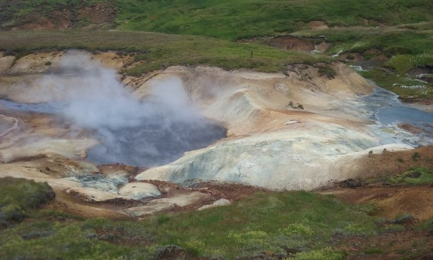
Bragi picked us up promptly at 1 p.m. and we headed for Iceland’s south coast on Highway 1, the country’s ring road. Our first stop was Hveragerði, Iceland’s leading greenhouse town. The area’s landscape is geothermally active, supporting both greenhouses and large geothermal power plants.


My particular interest was the geothermal pools, or hot pots thatP1030076 appeared after a series of earthquakes in the spring of 2008. I had hiked through the area in 2007, and had been amazed to return the next summer and find boiling mud pots a quarter mile uphill from the busy town. I was curious to see if they were still as active now, and what kind of visitor information had been added to the site.

I have to say that we probably would not have been aware of the geothermal pools if we had been casual visitors there. An agricultural university has grown up along the access road to the site, and there are no directional signs to the pools. There are safety ropes to keep visitors at a safe distance and occasional signs reminding of the danger of the very hot water:


SeljalandsfossFrom there we drove to Seljalandsfoss, one of the landmarks easy to spot while driving the coastal highway. It is a tall waterfall (foss means waterfall in Icelandic) that is visible for miles as it plummets about 200 feet off the coastal ridge. This one’s secret attraction is the opportunity to walk behind the falling water in a shallow overhang. The bad news is that every tour bus on this section of Highway 1 has an obligatory stop here. The parking lot is large but the trail is narrow and there is usually a line for the restrooms.


Tour buses stop long enough for their passengers to take the quarter mile hike up past the P1030079waterfall and return. Independent travelers can continue on the trail another half mile and view two hidden waterfalls in slot canyons. At that point in the summer, ladders necessary to view the first one easily and safely were missing. Bragi and I climbed high enough to get a glimpse of the falling water, but I don’t consider it worth the effort. The second falls were as I remembered— a surprising sight visible through a very narrow gorge. I had forgotten the watery access and wasn’t wearing waterproof boots, so I resisted entering the cavern for a closer view.


From there we headed to the village of Hvolsvöllur and our first lodging on the road, Guesthouse Kristján’s. I booked it through AirBnB.com, but the only room listed on that website has a double bed. The guest house offers several inexpensive rooms that share the basement kitchen, bath and laundry room. Until this trip I had understood an Icelandic double to mean two twin beds pushed together. It is clear that entrepreneurial Icelanders have figured out that a small room can be rented as lodging for two with a double bed when two twins won’t fit. Susan and I managed, but were not enthusiastic about the accommodations. Lesson learned. I will be more careful in the future.

The guesthouse is a two block walk from the ring road, where we found a nice café for dinner, the Eldstó Art Café/Bistro. It features a pottery gallery in the back rooms and should be a nice quiet local coffee shop in the off season. During the summer the place was hopping with tourists and a staff of college age young people who were very friendly, but seemed to have trouble figuring out which table was waiting for the order in their hands. My notes say I had a burger and a Tuborg light, but I just remember a good meal in interesting surroundings our first day on the road.