Category Archives: Uncategorized

GOLD MOUNTAIN LOOKOUTS – 2023 REVISION

RT Distance: 8 miles

High Point: 1760 feet

Elevation Gain: 1450 feet

Season: All Year

Discover Pass is required.

HISTORY

In 1948 the Washington State Division of Forestry raised a 75-foot Navy surplus steel tower with a small observation cabin on the high point of the long Gold Mountain ridge, the highest peak in Kitsap County. That cabin was too small for staff lodging, so a 14×18-foot ground house was provided on a shoulder of the ridge, about 50 feet downhill. [1] Sometime in 1965, the then Department of Natural Resources replaced the tall metal tower with a 50-foot wooden tower with a live-in cabin on top on the next hill to the southwest, less than 0.1 mile away.[2]

Gloria and Dick Tyler were the staff on the Gold Mountain Lookout towers in 1965 and 1966. Gloria wrote about their experiences there for the Department’s lookout staff newsletter, Ten˗Eight. She reported they were stranded in the tall old tower when a 70 mile an hour wind came through, June 17, 1965. They stayed overnight in the tower, because Gloria was afraid to go down the ladder in the wind. “It was still blowing in the morning but by then I was so cold and stiff I thought I might as well go dramatically,” she reported. [3] In the July 1966 issue, she reported they were enjoying the new lookout tower, and not needing to climb the old 85 foot ladder several times a day.[4] Historical lookout inventories report the second Gold Mountain Lookout as “destroyed 1971.”[5]

A half dozen television stations, communication companies, and government agencies have erected their relay towers along the two-mile ridge since that time. Trees have grown tall on the summit, concealing the route foresters took to the first lookout tower. A timber harvest authorized in 2023 may restore some of the panoramic views the historical fire lookouts enjoyed, sometime in the next few years. A cultural resources review of the area, which is required as part of the timber harvest planning process, should result in a “Save Trees Area” that leaves the artifacts of the 1948 fire lookout tower and ground house undisturbed.

HIKE SUMMARY

This hike visits both Gold Mountain Lookout sites. It begins at the Tin Mine trailhead in the Green Mountain State Forest and shares a narrow trail with mountain bikes for a short part of its ascent. Bikers appear mostly on weekends and are generally courteous. The trail connects with an old forest road crossing the Gold Mountain ridge on a route that primarily serves the modern communication towers standing tall above. The 1965 lookout site is easily reached by road. Access to the 1948 ground house and tower sites requires a short cross-country hill climb.

Getting There from Bremerton (coming from the east or north):

  • From Bremerton, take the Kitsap Way exit from State Route 3.
  • Drive 1.4 miles and take a slight left on Northlake Way NW.
  • At 2.5 miles, angle left on the Seabeck Highway NW.
  • At 5.5 miles, take the second exit at a traffic circle, to NW Holly Road.
  • At 9.7 miles, turn left on Lake Tahuya Road NW.
  • At 10.9 miles, turn left on to Gold Creek Road NW.
  • At 12.4 miles, turn left into the Gold Creek Trailhead parking lot of the Green Mountain State Forest. There are no signs announcing the approach to the parking lot, which is concealed behind foliage. Park between the outhouse and the picnic tables.

Getting there from Belfair (coming from the south):

  • Follow signs toward Belfair State Park from the traffic light on State Route 3, in the center of Belfair.
  •  In two blocks, turn right at the stop sign, onto the Old Belfair Highway.
  • At 3.5 miles from State Route 3 (just past MP 3), turn left on Bear Creek/DeWatto Road.
  • At 6.6 miles from State Route 3 (just past MP 3), turn right on NE Gold Creek Road.
  • At 9.0 miles, turn right into the parking lot. Small signs just before the entrance announce the approach to the Gold Creek Trailhead. Park between the outhouse and the picnic tables.

THE HIKING ROUTE:

Follow the Tin Mine Trail signed for non-motorized use that starts to the right of the outhouse. In 2023 this trail name appears on signs throughout the southern part of this state forest, but not on the Department of Natural Resources’ website. The map there is dated 2009.

Hike 0.25 mile on a narrow trail through a young forest to a junction marked with a metal diamond trail sign on a tree trunk on the left side of the main trail. Turn right before getting to the diamond marker, onto a trail which has been designed primarily as a challenge for mountain bikes. The track remains in the trees for little more than 100 feet, then emerges to climb a hillside that was closely shorn in 2019. A lot of logging debris was left in place, but small shrubs—notably sword ferns, Oregon grape, salal, and lupine—have started doing their best to restore the landscape. Clear views of the Olympic Mountains, Hood Canal and Lake Tahuya are revealed as you ascend the hill.

The trail winds steeply up the slope, gaining about 500 feet in 0.55 mile. Signs at the ridgetop indicate the Tin Mine Trail continues, traversing to the east from its junction with a one lane forest road.

Turn right on the road to continue toward Gold Mountain ridge. The road quickly turns south. On its left side is an abandoned gravel pit. The trees in this area were harvested early in this century, and their replacements are growing quickly. Continue on this track for 0.7 mile. In spring watch for purple lupine and the bright pink blossoms of native rhododendrons beside the road.

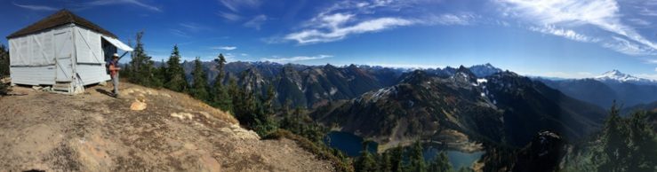
At 1.5 miles from the trailhead, the track meets the main gravel road on the Gold Mountain ridge. This is Minard Road, a name that appears on historical maps of the route to the Gold Mountain fire lookout. Continue traversing the ridge toward the northeast. Trees on the downhill side of the road were harvested between 2010 and 2015. Their replacements have grown slowly on the sunny slope, allowing a broad panoramic view from the Olympics to Mount Rainier. Mission, Tiger and Panther Lakes are visible to the southwest, near the foot of Gold Mountain. A snippet of Hood Canal can be seen far south of the lakes while large segments of Puget Sound’s waters appear to the southeast, with Mount Rainier floating above them on clear days.

The ridgetop is reached in about 0.25 mile as you pass a gate identifying the large installation down its spur road as belonging to KCPQ, Channel 13. The development includes a tower tall enough to disappear in passing clouds. Something in the complex hums insistently as hikers pass its northern boundary, distracting briefly from forest views and bird songs.

Turn east and continue on the ridge. Rhododendrons thrive on the shadier north side of the ridgeline. Pass a gated road on the right that leads to a tower belonging to KTBW-TV, Tacoma. Views of a comparable tower on Green Mountain, about a mile to the north, emerge on the left as well.

The road continues eastward. At 2.5 miles keep right at a Y junction. The ridge road reenters the forest where openings allow broad views east and north. After trending downhill, the route circles the eastern end of the ridge. As the gravel track turns west to complete the curve, it climbs steeply. At 3.5 miles the main road widens and an unsigned spur leads south toward a metal tower visible over the trees. This site was identified in Harvey Manning’s 1979 Footloose 4: Walks and Hikes around Puget Sound, as the site of the 1965 Gold Mountain fire lookout tower. [6] Research by Eric Willhite and Alan Mainwaring in February 2023 found the correct historical location a short distance west of the 1948 fire lookout site.[7]

Continue west another quarter mile, passing a junction with an ungated road on the right that leads to two communication towers. Pass a hillock on your right and follow the road downhill and up around a curve to its end on another hillock. At the right side of the road end are several small buildings and a tall communications tower inside a chain link fence. This is a Washington State Patrol communications station. On the left side of the clearing is an L shaped one story building, marked with a Washington Department of Natural Resources facilities inventory number on its east side. The structure’s current use is not known, but several artifacts of the 1965 fire lookout tower remain close to this building. Three square concrete footing blocks, each with a pair of short galvanized rods protruding, stand close to the foundation of the building which replaced their tower. The footing blocks are located so close to the newer building, it is unlikely they are in their original positions. Additional research will be needed to learn more detailed information about the location of the 1965 tower, and about the building which replaced it.

To visit the well-defined site of the 1948 fire lookout tower, retrace your steps to the low point on the road between the two hillocks. Notice an informal trail leading to a green transformer box about 100 feet to the left of the road and a few feet higher than the road. Several artifacts of the ground house which supported the 1948 fire lookout tower are within 50 feet of the transformer box. A white porcelain sink sits against the slope of the hill; a 6-x 4-foot section of corrugated metal roofing leans against a tree between the sink and the road; and a set of three concrete steps which provided entry to the lookout staff’s ground house stands on the east side of a sturdy fir tree which was probably a sapling in the 1960s.

Sink 1Steps 1


The informal trail continues up to the top of the hillock where the 1948 fire lookout tower stood. Discover an open area on the higher hillock, covered with moss. A bronze disc set in concrete crowns the hill. It is engraved US Coast and Geodetic Survey and has GOLD HILL 1954 stamped into its surface. This is the principal survey station marker for this location. About six feet to the west a bit of concrete sticks out, with the stub of an angle beam barely visible above the vegetation. Three angle beams are usually easy to find on this site, located just far enough apart to support the original 75-foot steel tower here. The bronze Reference Mark No.1 disc that stood in the center of the tower supports [8] was uncovered in winter 2022˗23, confirming the exact location of the original Gold Mountain lookout tower on the top of this hill.

You may also meet other explorers while visiting Gold Mountain. This peak has been identified on the internet as both the high point of Kitsap County and as a geocache site.


[1] State of Washington, Forty-Third and Forty-Fourth Annual Reports of the Division of Forestry for the Period Commencing January 1, 1947 and Ending October 31, 1948, p. 24.

[2] The Department of Natural Resources received authority to withdraw 10 acres of Forest Board lands at this location for a “lookout and electronic site,”. Order 63˗302 signed by Bert L. Cole, Commissioner of Public Lands, March 15, 1963.

[3] Gloria Tyler. Ten˗Eight, July 1965, [p. 3.]

[4] Gloria Tyler. Ten˗Eight, July 1966, [p. 2.]

[5] Ray Kresek. Fire Lookouts of the Northwest, 2019 Revised Lookout Inventory, 23.

[6] Harvey Manning, Footloose 4: Walks and Hikes around Puget Sound. Seattle, The Mountaineers, p. 210˗212.

[7] Willhite and Mainwaring found a series of documents from the 1960s in Washington Department of Natural Resources regional property files which record the withdrawal from timber management of 10 acres on Gold Mountain ridge for “fire lookout and electronics,” The 1948 lookout site is at the northern edge of this 10˗acre site.

[8] US National Geodetic Survey Data Sheet PID SY5508 GOLD HILL LOOKOUT TOWER: https://www.ngs.noaa.gov/cgi-bin/ds_mark.prl?PidBox=SY5508. 

MASON LAKE LOOKOUT SITE – ALTERNATE HIKE


This is offered as an easier route than Hike 35 in Lost Fire Lookout Hikes and Histories: Olympic Peninsula and Willapa Hills. It is still a short, low elevation, year round hike.

Drive to the junction of the Mason˗Benson Road and East Trails Road. Turn right on East Trails Road and drive almost one mile to a gated gravel road on the right. Park near Green Diamond gate number 2385.

Start your hike up the moderately sloped road beside Sherwood Creek. Trees have been retained close to the creek to protect water quality, offering a healthy mixed forest of cedars, hemlock, and fir on the left side of the hiking route. Keep left at the first Y, continuing to parallel the creek, which burbles audibly in winter and spring. Enjoy occasional views of the water, flowing broadly between thick grassy banks.

The road curves to the right (east southeast) at about 0.6 mile, tracing the water course that has gained a swampy patch featuring swamp lanterns (also known as skunk cabbage), before disappearing into dense forest.


At 0.8 mile the hike route turns southwest, away from the creek. After another quarter mile, take a grassy branch road to the right, continuing the moderate ascent through the tree farm. At 1.33 miles, this road ends at a logging landing on the top of a 260-foot-tall hill. Fortunately, the route’s continuation is visible a few hundred yards away, on the next small hill to the southwest. This short section of the road was half-heartedly covered with logging debris after the last harvest here, around 2018. Step over the small downed limbs, and continue your hike. Descending from the second hillock, a crossroad appears in a few hundred yards. When you reach it at 1.7 miles, turn right.


The original route turns left at the next junction, crosses a culvert, then climbs the next ridge on an old jeep track through evergreen huckleberry bushes and young fir trees. Instead, this alternate route continues on the narrow road headed north northeast for another quarter mile, then turns left at the next road junction, to hike southwest between conifers planted in the 21st century. This road’s border includes alder, manzanita, and scotch broom among its young fir trees.


After traveling about 0.4 mile to the southwest, turn left uphill on a narrow but drivable track. Hike a short distance to the viewpoint at the end of the road. No artifacts of the old fire lookout building have been found here, but the high point of this area is beside the ridge-climbing road, at 362 feet elevation. The high point’s coordinates are 47.3473°, ˗122.9145°. The best views are found here too. The view east offers a grand panorama of Mount Rainier and the Cascades. The western horizon features Mounts Elinor and Washington’s snowy peaks, among the Olympics’ rocky skyline.

When satisfied, descend the narrow road and turn right to complete the loop. Bypass a lesser road headed west on the left, but take the next left turn at a T. In another 0.1 mile, turn left again on the road that runs beside Sherwood Creek. You have completed the loop; the trailhead is just 0.15 mile ahead.

KELLY LOOKOUT HIKE EXTENSION

I have always enjoyed hiking to the Kelly Lookout site on the Mason ˗ Grays Harbor County border, and wondered where the roads connecting with the hike route go. Knowing the fire lookout station was on a low elevation ridge between the Middle Fork Satsop and the Canyon Rivers, with lots of hills and valleys interspersed, has intrigued me. Maps of the area are spider webbed with gated forest roads, making it an attractive area to hike throughout the year.

            The map below shows a 6.5-mile loop route with several side roads (thin black dotted lines) you may want to add to your exploration. Start at the junction of the gated Green Diamond Forest Road 6850 with the main haul road through the area, which has several names and no road signs in 2022. My 2007 National Geographic Topo digital background map labels it the Kelly Road. Washington DNR quadrangle maps of similar vintage label it the 500 Road. I remember seeing a road sign with that number, but I have also seen it called the 6800 Road— a number that is appropriate for the Green Diamond road number system.

            Hike up the road from the gate. It soon turns a corner and levels out a bit, then rises again a couple times before reaching the critical Y at about 0.75 mile. Keep right at the Y junction to visit the Kelly Fire Lookout site. Chapter 43 has a more detailed description, if you would like one.

            After visiting the fire lookout site with its green painted artifacts, the first option is to continue down the hill to a logging landing which currently has clear views into the valleys east and west. The rivers are not visible, but forested slopes and landscapes shaped by millennia of water carving through rocks and soil spread in all directions. 

            Return to the Y (where you kept right to visit the Kelly Lookout site). Turn right to continue around the loop. The route is comprised of narrow roads curving through rolling forestland. The curves prevent long views of the road ahead. Tree harvests in this century provide intermittent side views into broad forests as the hike route continues northeast. Self ˗seeded hemlock sprouts border the roadway, along with vigorous salal. The forest is generally a mix of Douglas firs and hemlocks, with occasional cedars and alders.

            The next major junction is at a corner with a 6850 road sign on the left. A side road on the right leads southeast, toward the Satsop River. I have not followed that branch. If you do, and it leads to a riverbank, please let me know. The loop route heads north from here.

            At K˗1 on the map (coordinates 47° 17′ 07″ N, 123° 29’’35″ W), follow the road left into a shadier section of the forest. The attractive uphill road on the right unfortunately ends in a logging landing in about a quarter mile. Continuing on the main route is a better choice here.

            This section of roadway travels northwest, with one surprise in the forest landscape. There is a logger’s memorial on a tree beside the track. A tin logger’s hardhat has been fastened high on a sturdy tree trunk on the right side of the road. It has been there long enough for bark to grow over the hardhat’s rim. A plastic vine with red flowers is draped over tree limbs just below the silver hat. Several other memorabilia, including a date plaque (12˗10˗12), sit at the foot of the broad tree base.

Not far beyond this landmark, the route turns left at a gate and continues a short distance southwest to reach K˗2 on the map. K˗2 marks the junction with a side road on the right that could have a panoramic view west—if a few trees fell or were felled. Only narrow gaps between the trees were found when the 0.4˗mile spur was explored in 2020. Perhaps it has improved.

            Turn left at K˗3 to include an interesting decommissioned road in the hike route (at coordinates 47° 17′ 11″ N, 123° 30’’36″ W). The landscape slopes downhill on the left toward an occasionally visible valley, and uphill on the right. The 1.2˗mile road was closed with two sets of berms and ditches. The first set is shallow; walking around the berm and across the depression requires little if any close attention. The second set has higher berms and an eight-foot-deep ditch with a usually thick mud bottom. An eight-foot-long split tree trunk and rocks were left in the winter mud in 2022 as a temporary aid for foot traffic. Cross with caution.

            Although we lacked a thermometer to test our intuitive assessment, the last section of the decommissioned road seemed significantly cooler than the rest of the route. In early February 2022 the only patches of snow we saw on the entire hike were beside the road in this part of the route. It does not have the highest elevation on the hike, and it did not appear especially shady, but it was definitely cooler. A look at the map reveals this section of the path parallels an unnamed creek that runs into the Canyon River a half mile west of the Kelly Road. The nearby creek may well contribute to the cooler microclimate experienced here.            

The decommissioned road ends on a maintained gravel road which is gated at its junction with the 500 or Kelly Road. Turn left at K˗4 on the map. Hike 0.6 mile to return to the trailhead and your vehicle. Keep an eye out for the creek crossing under the roadway in a forested valley. It is one of the subtle waterways that were the first designers of the area’s interesting landscape

THE SKETCHY HISTORY OF THE RAFT FIRE LOOKOUT

In October 2019 I organized a slide show about local fire lookouts for The Olympians Hiking Club in Aberdeen. I planned to share photos and what I knew and remembered from visiting all of the lookout sites in Grays Harbor County. Almost all of the historic fire lookouts there had been eradicated—with almost all signs of their existence removed before twenty-first century visitors arrived on the scene.

On my list was the Raft Lookout site, which I had hiked to several times in 2008-2010. I wasn’t including it in my book, because maps now show its location on the Quinault Indian Reservation, and the tribe no longer offers recreation permits for access on their lands.

To gather a little history for my presentation, I looked in the lookout inventories published in the 1980s. I noticed that Raft is listed in Byron Fish and Ira Spring’s Lookouts; Fire Watchers of the Olympics and Cascades, but does not appear in either of Ray Kresek’s books about lookouts published in the 20th century.[1] Fish and Spring list Raft lookout under the Olympic National Forest and Olympic National Park, Quinault Ranger District. It describes it as a “Lookout shown on Forest Service map and not on USGS.” They located it in “Township 23 Range 11W Section 12, 10 mi. NW of Amanda Park.’[2]

At some point, based on the research of volunteer historians and lookout hunters like me, Raft’s name was added to the updated lookout lists in both the 2015 and 2019 editions of Kresek’s Fire Lookouts of the Northwest; Lookout Inventory Revised. The line for Raft says only “Raft… (see Salmon River).”[3]

That surprised me, as I think of Raft as a federal fire lookout and Salmon River as state, so I pulled out my older maps of the region. Some have accumulated on our bookshelves along with hike guidebooks since we moved here in the 1970s, a few were gifts from older friends when they were downsizing, and one prize 1960 Quinault District Firemans [sic] Map had been sent to answer my questions about another fire lookout site. Several of these maps[4] show Raft as a forest service lookout in 1960 through 1976 at least, and Salmon River[5] as a state lookout—just as they are both listed in the Fish and Spring book.[6] At the talk, I had no photo of Raft Lookout to show, and only my map discoveries to support my scanty knowledge of Raft’s existence.

A section of the 1960 Quinault Ranger District Firemans map, marking the locations of fire lookouts in the Olympic National Forest and Quinault Indian Reservation with black triangles with white centers: Raft River Ridge and Higley Peak in the national forest, and Lone Mtn. on the reservation. This map lacks a legend interpreting the symbols used.

1972 Olympic National Forest map, showing the locations of the Raft Lookout (hexagon), Raft National Geodetic survey marker (triangle), the Salmon River Lookout (triangle within a hexagon) in the Olympic National Forest (green), and Lone Mtn. survey marker (triangle) within the Quinault Indian Reservation (pink). Fire lookout symbols were not included in the Olympic Forest and Park map legends in the 1970s or later.
1977 Olympic National Forest, Olympic National Park map, showing the locations of the Raft Lookout (hexagon), Raft National Geodetic survey marker (triangle), the Salmon River Lookout (triangle within a hexagon) in the Olympic National Forest (green), and Lone Mtn. survey marker (triangle) in the Quinault Indian Reservation (pink). Fire lookout symbols were not included in the Olympic Forest and Park map legends in the 1970s or later.

There wasn’t a large crowd for my Olympian slideshow, but a number of people stayed after the presentation to ask questions and share memories. I had hiked with more than half of the people in the room, so I anticipated hiking memories, and few questions. I was a little surprised when a frequent hiking companion from Elma mentioned that he remembered seeing the Raft Fire Lookout. He had worked for the Olympic National Forest several summers in the late 1960s, based at the Matheny Forest Service Work Camp. The Camp was located a few miles north of the Raft lookout, on Forest Road 240 (I think it is FR 21 on current maps) at the Jefferson County line.

The Raft Ridge Lookout, as he knew it, was one that his crew checked on regularly. He remembered there had been a house trailer on the site in 1968, ‘69 and 1970. His other clear memory was looking down on the Lone Mountain Lookout tower,[7] across US Highway 101 to the southeast, in the Quinault Indian Reservation. The Raft Fire Lookout, even without a tower sat at 1600΄ or 1700΄ elevation, while the Lone Mountain Tower added a 90΄ metal tower to its 1173΄ hilltop elevation.

The combination of symbols on maps and the memories of an elder forest worker resolved the Raft Lookout question for me. Byron Fish and Ira Spring were correct to trust the US Forest Service map when they included Raft as a federal Forest Service fire lookout in their 1983 book.

That left one related mystery for me—how, when and why was the land that had included both the Raft and Salmon River Fire Lookouts transferred to the Quinault Indian Nation? I recently learned the area was known as the North Boundary Expansion Area.

… But that is a story for another day.

[1] Ray Kresek, Fire Lookouts of Oregon & Washington, 1985 and Fire Lookouts of the Northwest, 1984.

[2] Fish and Spring, p. 197. [1] Kresek, 2015 and 2019, p. 23.

[3] Ray Kresek, Fire Lookouts of Oregon & Washington, 1985 and Fire Lookouts of the Northwest, 1984.

[4] Fish and Spring, p. 197.

[5] Kresek, 2015 and 2019, p. 23.

[6] Quinault Ranger District, Olympic National Forest, Firemans [sic] Map, 1960; Olympic National Forest map, 1972; Olympic National Park and Olympic National Forest. 1977.

[7] The Salmon River Lookout is documented elsewhere as in use from 1960 until about 1995.

[8] Byron Fish and Ira Spring. Lookouts; Fire Watchers of the Olympics and Cascades, 3rd edition, 1998, pp 197, 199.

[9] After several attempts, I reached Lone Mountain’s partly overgrown metal tower in September 2007. The tower was visible to travelers driving south on Highway 101 until 2012, when it was taken down for safety reasons.