HIKE SUMMARY: This is a good example of hikes in the Capitol State Forest. There are several ways to reach the destination; each involves numerous junctions and a few road crossings. Trail conditions come and go, as do the well-intended trail signs. The trails to Rock Candy Mountain are shared with bicycles all year, and motorized bikes May through November. Despite these drawbacks, the views of snow-topped Cascade and Olympic peaks can be wonderful, and sections of the forest are truly beautiful. The convenience of the hike to the state capitol area cannot be beat.
| Round trip Distance | High Point | Elevation Gain | Season |
| 6.4 miles | 2364 feet | 1700 feet | Year-round; Best: April |
GETTING THERE
- From Interstate 5 in Olympia, exit to US Highway 101 northbound.
- Drive west 5.8 miles and keep left on State Route 8, where US Highway 101 turns north.
- Pass milepost 17. Get in the left lane to exit left.
- A road sign indicates a left turn to the Rock Candy Mountain Road and a right turn to Summit Lake. Pull into the median left turn lane and cross the two eastbound lanes to enter the Capitol State Forest.
- Drive a short distance and park in the parking lot on the right, or adjacent to it during the winter season when the lot is gated.
- The trailhead is across the road from the parking lot.
HIKING ROUTE: Cross the road to a clearly marked trailhead for the Rock Candy and North Rim #1 trails. Do not let the trail names draw you in. The route that starts with the North Rim #1 Trail offers the most direct hiking path to Rock Candy Mountain. The route of the Rock Candy Trail is more than 2 miles longer and goes to the same destination. The 0.1-mile trail shared by the two routes briefly crosses open land before entering the forest. In winter 2022, the trail and land between the trail and creek showed clear signs of flooding that scoured the trail and forest floor.
The trail splits under the trees, with the Rock Candy Trail crossing an attractive bridge and heading east. The North Rim #1 Trail heads south into a mixed forest without any enticements beyond a well-maintained walking surface. The route’s first road crossing appears at 0.33 mile.
A sign before the road indicates the non-motorized trail ends here. About 100 feet into the trail across the road is a narrow brown sign confirming the North Rim #1 Trail’s continuation. A few corners later, the trail turns south and passes a recently replanted area with two spindly groves of seed trees offering filtered views of the south Olympics and western Capitol Forest.
At 0.8 mile, turn left (east) at a 3-way intersection. The sign here in early 2022 says North Rim Trail continues east and west. Maps indicate the North Rim Trail continues west from this point, not continuing toward Rock Candy Mountain.At 1.16 miles cross another section of old forest road whose use is now reserved for two-wheeled, horse, and hiking traffic. The shared trail starts with concrete trail support blocks, necessary for the heavy wheeled traffic. This fortunately leads to what is currently the prettiest section of trail ascending the west slope to the Rock Candy Mountain Lookout site.
The route climbs the hill in moderately steep zigzags, with more and more of the Olympic Mountains appearing as you ascend. The evergreens are tall here, making them subject to future timber harvest projects. The forest currently contains a mixture of conifers and low shrubs, with hedges of Oregon grape, sword ferns, and other native flowering and evergreen plants often bordering the trail.
At 1.8 miles, the trail ends just past a Divide Trail North sign. Turn right on a drivable road currently identified as the Divide Trail North on Capitol Forest maps. The west slope of this section of the ridge was harvested, 2018˗2021, offering broader views in that direction. In a short distance there are additional wooden signs on the left side of the road, identifying the destinations of downhill trails as Waddell Creek and Porter Creek.
Continue on the broad gravel road as it gradually becomes steeper, turns right, then left. At 2.5 miles it reaches a grand viewpoint offering Mount Rainier, Mount Adams, and Mount St. Helens to the east, and a panoramic forested landscape at your feet.
The elevation is about 1700 feet, indicating that most of the elevation gain for the hike has been completed. After admiring the view from the road edge, cross the gravel to a fairly steep bank marked with informal trails. In 2021 several former trails resolved into one shared by hikers, bikers, and dirt bikes. Ten to twelve feet above the road this informal way-trail levels out and wanders through open forest. The route ascends very gradually at first, becoming steeper after 0.25 mile, when it approaches an area with sky visible above young trees.
The clearing is a road end; the road continues the gradual elevation increase for another 0.15 mile. When the road you are hiking veers to the right, take the trail opening in tall salal on the left side of the road, continuing the straight route. Follow the trail through salal and forest for little more than a 0.1 mile, where it emerges at a hilltop road end.
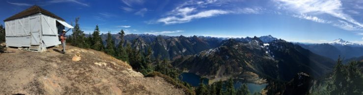
This is the top of Rock Candy Mountain and the site of its fire lookout. The curiously named hill offers panoramic views west and north, over many miles of forest to the Olympics and possible glimpses of the southern bays of Puget Sound. Most of the timbered acreage between here and the Pacific Ocean, and south to the Columbia River, is privately owned. There are only eight publicly accessible fire lookout sites outside of Capitol Forest in the Willapa Hills. Almost all you can see is commercial timber—private tree farms—grown to be harvested repeatedly with little regard for ecosystem health or wildlife.[1]
[1] This opinion echoes that of Robert Michael Pyle in his award-winning book about the Willapa Hills, Wintergreen, Listening to the Land’s Heart.
