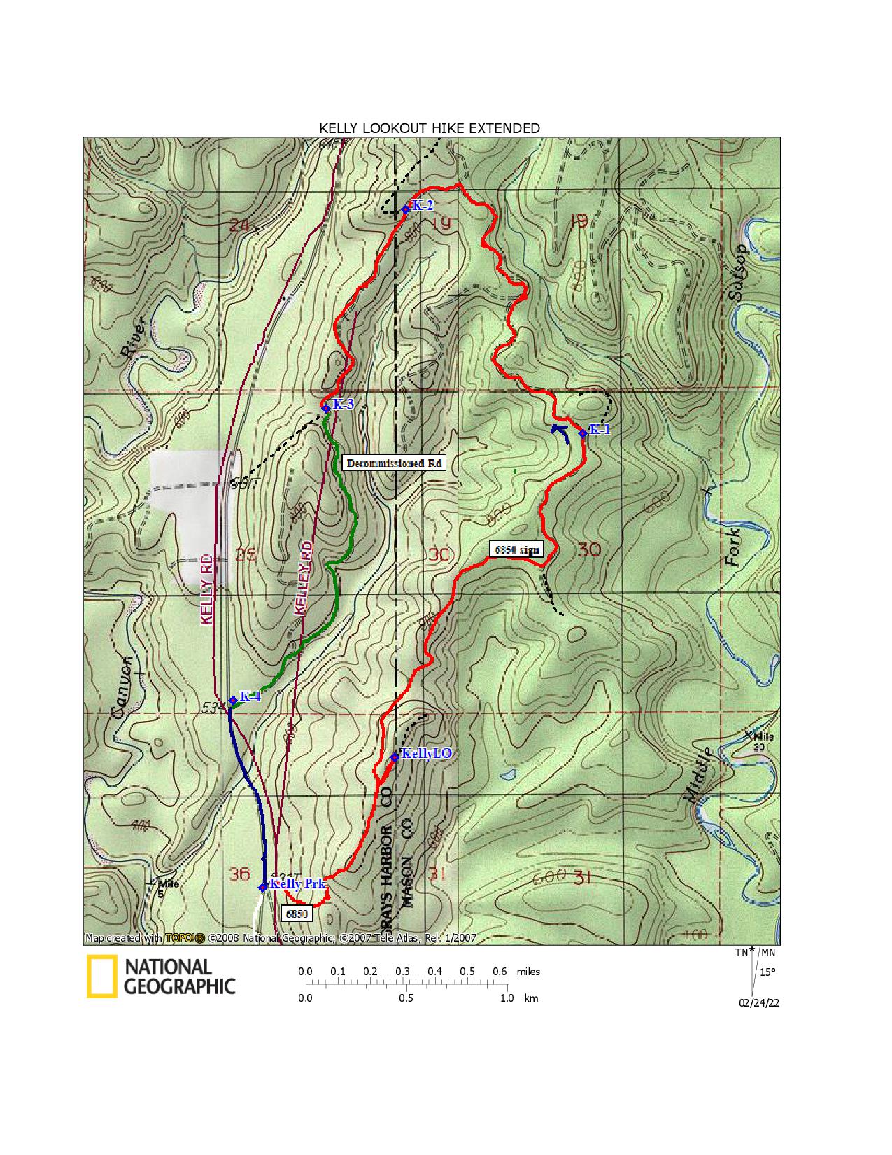
OVERVIEW
- Round Trip Distance: 4.3 ˗ 5.3 miles
- High Point: 2640 feet
- Elevation Gain: 600 ˗ 900 feet
- Season: May to November
- No Pass is required
This is offered as an easier route than Hike 47 in Lost Fire Lookout Hikes and Histories: Olympic Peninsula and Willapa Hills. Both the hike distance and the elevation gain are substantially reduced from the description in the book; the actual numbers will be determined by how far you drive on Forest Road (FR) 2371.
Background: FR 2371 is part of the first route I ever hiked to a location identified as the Weatherwax lookout site—but that destination turned out to be the wrong place. The Weatherwax fire lookout was known to be a state forestry watch tower, so it seemed reasonable that it would be on private or state forest land, rather in the Olympic National Forest —federal jurisdiction. Research in the last decade identified the current destination, close to the southern border of the Olympic National Forest but within its boundaries, as the correct location of the historical Weatherwax lookout tower site. One of my early questions for Keith Hoofnagle, who served as lookout staff at the Weatherwax fire tower in the early1960s, was whether the lookout had been located there by accident or with an intergovernmental agreement. He told me that Weatherwax being inside the national forest was well known to Washington Department of Natural Resources officials and employees. I don’t think he knew the legal details.
When I tried to hike this route in 2018, a gated road section, FR 200—which is within the national forest and links the national forest road 2371 with FR 210, which serves private forest land on Weatherwax ridge—was crowded with evergreen saplings, and I gave up on this road as a workable hiking route to the lookout site. In summer 2023, a lookout hunter friend decided to try the shorter FR 2371 route to the Weatherwax lookout site, and let me know that the gated half mile road linking sections of this route is now clear. Apparently a new agreement on use of the gated road had been reached and the road cleared of its young forest, making the route accessible to authorized vehicles and hikers.
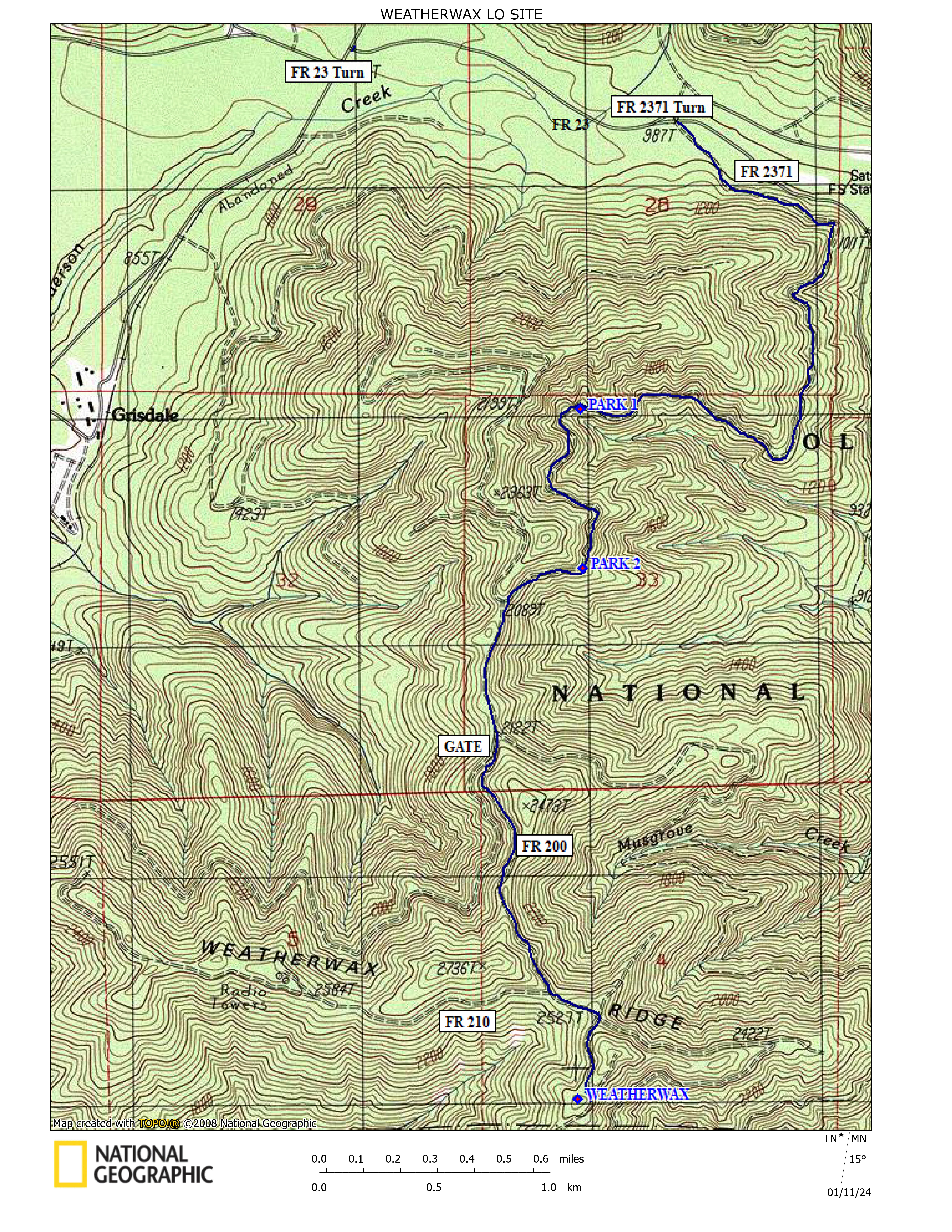
GETTING THERE
- Drive the paved Wynoochee River Road from US Highway 12 past mile post 33 to Forest Road (FR) 23.
- Turn right on the usually bumpy gravel FR 23.
- Drive 0.9 mile; keep right at a Y.
- In another 0.1 mile, turn right on FR 2371. The road number appears on a small sign on the left side of that forest road.
ROAD AND PARKING INFORMATION
The starting point for this hike is the parking spot you select on FR 2371 in the Olympic National Forest, between Lake Wynoochee and Satsop Lakes. In autumn 2023 this one lane gravel road was in good driving condition for most vehicles. Large rocks do roll down onto the track from the adjacent vertical walls, and trees come down in winter, so caution is advised.
The length of your hike is determined by your parking location. There are clearings on the left side of the road large enough for several SUVs at 2.0 and 2.6 miles from the junction of FR 23 with FR 2371. These spaces will allow hikes of 5.3 and 4.3 miles round-trip to the Weatherwax fire lookout site. If you want an even shorter hike, it may be possible to drive to gate200, about 4 miles from FR 23.
When last visited, there was yellow˗green flagging tape at the 2.0-mile parking site, and pink flagging at the 2.6-mile site—making them easier to identify. An interesting high rock wall rises from the west side of the road opposite the parking space at 2.0 miles. On a recent trip, my hiking companions got into a discussion of its origin as we prepared to start our hike. Sedimentary? Igneous? We wished we knew more about Olympic Mountain geology.
HIKE DESCRIPTION
The parking space is bordered by evergreen huckleberry bushes and conifers that descend the steep slope toward the West Fork Satsop River to the east. The one lane road/hiking route starts climbing while tracing a curve, offering a quick warmup at the beginning. The GPS track said it was only a 300 foot gain to the next junction, but it felt like more. In a little less than a mile a side road cuts off to the northwest, disappearing behind a high narrow ridge. Our route continues south on the now narrow ridge, with forested downhill slopes on both sides of the track.
At about 1.4 miles and 2120 feet elevation, the one closed gate on the hike appears straight ahead. FR 2371 continues as a drivable but little traveled road turning left and southeast at this junction. A rarely used grassy track angles off downhill to the right and south-southwest, while our hiking route continues south, past the gate labelled 200.
Hike uphill through healthy evergreen forest, gaining occasional views through the trees to the east. At 2.3 miles and 2460 feet elevation our route meets a wider forest road at a T junction. A small sign on the road to the right identifies that branch as 210. FR 210 ends in a clearing that is the location of the communication towers that can be seen on Weatherwax Ridge from the Wynoochee Valley Road far below.
Across the intersection a broad tree is marked with a large bold 12, showing hikers that drivers of large trucks used CB to communicate their locations along the road when the marking was fresh.
The hiking route goes left from the intersection, then curves to the right. A large bold 10 marks a tree on the right here. At a little more than 2.5 miles from the first parking spot and about 2600 feet elevation, watch for old tracks disappearing into the forest on both sides of the road.
As hiking to Weatherwax lookout site has gotten more popular, colorful flagging tape has been added to the shrubs and tree limbs on the right side of this old intersection, strongly suggesting the way to go. There is a low rise between the current road and the old road that served the Weatherwax fire lookout tower in the 1960s. Choose your path up the bank and through the vegetation. That hikers use multiple routes, rather than always following one path, should help reduce erosion.
The old road disappears, but level ground skirts the plateau edge on the right. Walk between the trees and shrubs, following the edge of the drop-off. The first artifact to find is the US Geological Survey (USGS) marker on a 10-inch tall metal post, identifying the azimuth point for the USGS Weatherwax survey station located across the valley, near the end of FR 210.
The other artifacts mentioned in Lost Fire Lookout Hikes and Histories: Olympic Peninsula and Willapa Hills were still on site when I visited the location in November 2023. Please leave them in place for others to discover in their turn.
The footing blocks for the historical wooden tower are yet to be found. If your time and curiosity support it, consider exploring the wooded slopes west and northwest of the hilltop for some of the missing pieces. Concrete can roll or be bulldozed downhill, but it doesn’t easily melt into the landscape.