From December 2015 until December 2017, I had an opportunity to occasionally explore Fort Lewis for the remains of the five fire lookout towers that watched over that area, starting in the 1940s. Four are gone. Goodman Hill Lookout was still standing at that time; its current status is unknown.
The essay below describes our initial encounter with the military structure that governed our access to the base. On the day recorded below, my friends and I were able to visit the Deschutes Tower site. We later visited the Garrison Hill Lookout site and the Rainier Tower site. The sites of the Goodman Hill Lookout and the less well-known fifth fire lookout station, Nisqually, were not accessible when we were available to visit the base. Update: April 6, 2020
We set out on a drippy Monday morning for JBLM (Joint Base Lewis McChord). I had learned there are recreational passes available that would allow us to hike on the 86,000 acres of Fort Lewis Training Areas for the next two years! Step 1 to obtaining such a permit is a one-day pass obtained at the JBLM Visitors Center, just outside the Main Gate, on the south side of Interstate 5 at Exit 120. A quick talking receptionist had said all we needed to get day passes would be drivers’ licenses for identification, plus registration and proof of vehicle insurance for the car we drove onto the base.
The Visitors Center is a very plain rectangular building sited behind a parking lot for about 60 cars. It was half full when we arrived, so we were not surprised to find a fairly full waiting room with rows of chairs and a take-a-number-for-service machine. Despite the crowd, the process went pretty quickly. Each of the four of us took our turn, produced our driver’s license and answered a few questions. I think I was the only one who could answer, “Yes, I have been on the base before.” A decade earlier, I had led a hike on the base as part of a Fort Lewis Recreational Program. My hike had gone to the one standing lookout tower on the base, at Goodman Hill. This was my first return to the military reserve.
With our temporary photo ID visitor passes, we easily entered through the carefully guarded multi-lane gate. The map I had reviewed before our trip clearly indicated that the Range Control Area Access Office was at the intersection of Stryker and Kaufman, and appeared to be straight in from the gate. I later figured out that one of the major flaws of our initial small scale map was that the gates were not clearly labeled. We had entered through a different gate.
We continued on what seemed to be the main road for about a mile. Then we came to an intersection with Stryker Avenue. We could only drive to the left, as the right side of the intersection was blocked to protect a residential area from through traffic. We knew the building number for our destination, but soon figured out that the numbers were descending, while we were looking for a larger number. Noticing one person on foot in an adjacent parking lot, we drove right up to him.
“Excuse me! Can you help us?” Once we had the attention of the competent looking man in uniform, we asked our real question: “Can you tell us where we can find the Range Area Access Control Office? It is supposed to be at building 4074 on Stryker, but we haven’t found it.”
“Sorry,” he replied. “I have only been here a couple weeks, and am still trying to find my way around.” He suggested that we continue in our current direction for half a mile, and if we did not find it, turn around. We agreed, drove past some open fields and were in sight of another gate when we decided it was high time we retraced our route.
Meanwhile, our designated navigator had gotten a Google Map working on her phone and found the street intersection we wanted. Sure enough, it was about as far beyond the main road we had driven in on as our farthest exploration. In the next few minutes we drove through blocks of drab office buildings and then a section of two story brick residences that had been housing army officers since World War II. At the intersection of Stryker and Kaufman we found a long narrow clapboard building that looked as if it belonged next to a 1940s railroad track. It was clearly marked: Range Control Area Access Office.
We climbed the short flight of stairs to the raised walkway that ran the length of the building. There was only one door near the stairs, and the information on it didn’t make any more sense to us than the name of the office, but we were confident we had come to the right place.
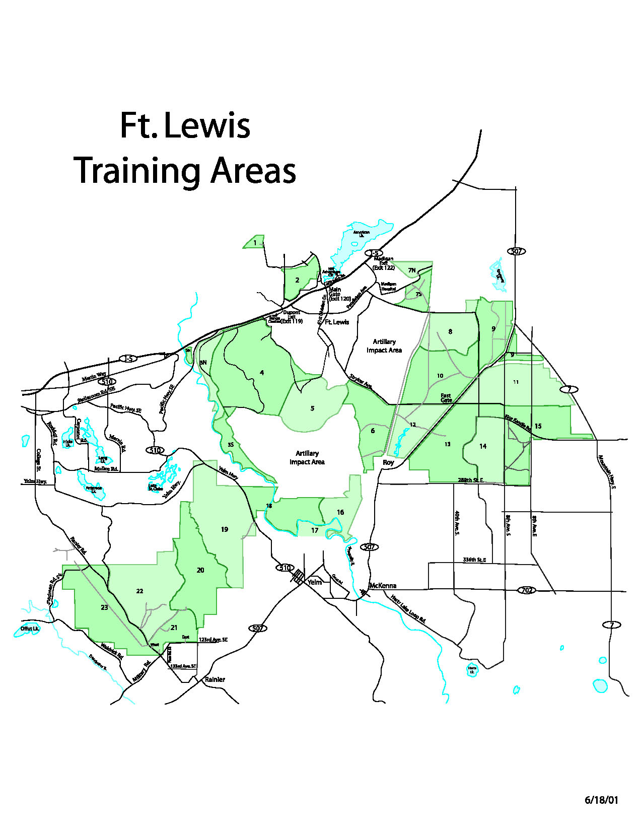
The door opened to a small lobby with a chest high counter on the left, staffed by three young soldiers. On the wall to the right was a large map of the Fort, with a couple dozen colored areas of various shapes and sizes, each marked with its own number.
The young soldiers asked us a few questions – what would you like to do in the training areas – their assumptions being that we most likely wanted to ride our horses or walk our dogs on the base. When we admitted we did not know exactly where we wanted to go, we were referred to the big map – probably six feet by six feet. There we discovered that we could not only figure out which Training Area each of our lookout sites was located in, but most of the locations were marked with tower icons!
Courtesy of http://www.capitolriders.org
The desk staff waited patiently while we made our discoveries on their lovely large map and wrote down the number of each range containing a lookout site. Then one soldier explained how their system works, and how one gets to visit a particular area.
Whenever one wants to visit a Training Area, you phone the recorded message at (253) 967-6277 and learn which Training Areas are open for visiting that day and the next. When you decide to visit one of the open Training Areas, you respond to the questions at the end of the recording: • What Training Area or Areas will you visit?
• What date will you visit it or them?
• What hours do you expect to be there?
• What is your name and Access Permit Number?
• Will other Access Permit Numbers accompany you?
Okay! Now we thought we were ready to go exploring. It was only 11 a.m., so we had plenty of day left. There was a long list of Training Areas open that day (and most days, we learned). But none of them matched areas we wanted to visit.
We then learned that a few Training Areas are permanently closed. A few were closed because they are critical habitat for species that survive in only a few areas in the region. The Taylor’s checkerspot butterfly and the streaked horn lark are the creatures identified as protected here, while other rare plants and animals benefit from the reduced human traffic. Another area has been permanently closed because a helicopter spooked a horse there, the rider fell off and was injured, complained and the area was closed to recreational access.
That training area is in my home county, and the lookout site located there is one that I had visited several times a decade ago. I knew that the route to the site of the former tower there goes only a quarter mile off a county road with scattered houses on both sides. When I mentioned this to my friends, the soldier agreed that it would be easy to visit.
So we completed our Monday adventure by returning to more familiar territory. We drove south on I-5, took a connector road to Old Highway 99, turned left at the old blue roadhouse, and drove until we crossed the railroad tracks and the rail trail. We parked at a wide spot beside the trail and hiked back along the road until we came to a “Federal Property No Trespassing” sign behind a chain link fence. We followed the fence for about a hundred feet to an opening, legitimized by two tall posts and no forbidding signs. It led to a gravel road that wound to the top of the hill. The last time I had visited, cement blocks stood there that had formerly supported the legs of a 100-foot metal lookout tower. Beside the blocks had been a burnt out car body and signs of weekend keggers. Now the site was clean. All signs of the site’s history were gone. The road through the area ran in a small circle at the top of the hill, suggesting a focal point that no longer existed. There we ate our late lunch and discussed when we might use our new permits again.
Useful links: http://www.seattletimes.com/seattle-news/fort-lewis-open-for-recreational-activities/
http://www.lewis-mcchord.army.mil/DPTMS/training/range/docs/aabrochure.pdf