Author Archives: leslieromer

WANT TO KNOW MORE ABOUT THIS YEAR’S ERUPTION?

Icelandmag.is

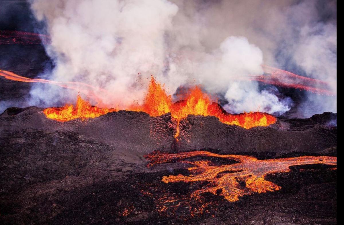
Photo from  www.Icelandmag.com

Bárðarbunga (bowr-thar-buhn-ga), one of Iceland’s most productive volcanoes, began an eruption in late August and has not stopped yet (4th week of October). Since the lava arrived on the earth’s surface through a crack in an old lava field called Holuhraun (ho-lu-hroin), it is often called the Holuhraun eruption. Bárðarbunga has a large crater deep under Iceland’s biggest ice cap and fissure fields running both north and south. It has erupted in both directions in the past, but it is far from populated areas so its history is better known through modern scientific studies than eyewitness accounts.

The current eruption shows up occasionally in the US news media and internet commentary, but unfortunately the information there is not always reliable. You can probably trust that photographs labeled as images of Bárðarbunga are showing the correct volcano. But if you want more information, your best bet is either the English version of an Icelandic website or a blog. (If most of the words on a webpage are Icelandic, look for the word ´’English,’’ or the little Union Jack flag at the top of the page.)

For the basic official information, visit www.vedur.is. It is the Icelandic Meteorological Office´s website and has a daily report of Bárðarbunga´s seismic and eruptive activity starting on August 16. You may have learned elsewhere that the eruption began on Friday, August 29. I have seen the date given as August 31, too, but the scientists reported ´a small fissure eruption (600 m/.4 mi long) on an old fissure in the Holuhraun lava field’ on August 29. They did report an explosive eruption on August 31, but one shouldn´t need lava fountains rising hundreds of meters or feet into the air to recognize an eruption!

Reading the daily reports made me wonder how the geologists in the field knew that this would really be an eruption before it happened. Yes, there was lots of seismic activity and earthquakes were occurring in both the big caldera beside Iceland´s second highest mountain and 40 km/25 mi to the northeast, under the Dyngjajökull (din-gya-yoe-koetl) outlet glacier. Geologists have been warning about imminent eruptions, based on seismic activity as long as I have been aware of active volcanoes. How has this one been different? It is true that the distance between the two sets of tremors kept increasing, with the northerly set working its way out from under the edge of Dyngjajökull´s ice. When the eruption started on August 29, it was well north of the glacier. Lava appeared and then some steam.

And what makes me think they knew it was coming? The activity log provided on http://www.vedur.is starts with the August 16 reports. The first report says Bárðarbunga´s very large caldera (11 km/7 mi wide) is covered with ice 850 m/2800 ft thick and could erupt at any time – and anywhere up to 100 km/62 mi away. The very next day they reported the installation of a permanent seismic station on Dyngjajökull, at one of two sites in the area geologists had been testing since January. Were they just lucky, or did they somehow know that the current earthquake swarm would lead to an eruption?
The weather website provides links to other official websites too, in case you are interested in road closures or health hazards. Iceland has lots of international visitors, so they want to get the word out that the area is considered the most dangerous in Iceland right now, and they would like non-scientists to stay away. The Icelandic Directorate of Health is taking the health hazards of sulfur dioxide (SO2) in the eruption clouds seriously too. They warn anyone who feels their breathing affected by the air pollutant to stay indoors, close their windows, and turn off their air-conditioning and keep up the heat keep the SO2 outside. With the SO2 output now measuring 35,000 tons per day, scientists working near the eruption are required to wear gas masks and always keep gas monitors tracking their exposure. Health officials provide everyone with daily warnings of the direction of the emission cloud. With two-thirds of the country´s population living in the Reykjavík area, public media seems to pay more attention when the wind is blowing toward the southwest.
But those are only the official government reports. There are other perspectives available: RUV, Iceland´s big television broadcaster, provides some news highlights on their website, www.RUV.is, too. That´s where I learned that some curious Icelanders ignored the road closure warnings, at least before the first snow arrived in late September. The TV news reported on September 21 that authorities had found six new off-road trails into the closed area and arrested some jeep drivers and their passengers. They reminded people that the gas emissions from the eruption were killing birds in the area and weren´t healthy for humans either. About a week later RUV´s photos of the eruptions featured snow in the foreground. Northeast Iceland was blanketed with snow, and not just on the mountain tops. As part of their warning to trespassers, the Civil Protection Service announced that they are prepared to evacuate the 20 – 30 scientists working near the eruption, but cannot guarantee their ability to get many more people out of the area in an emergency. Similar newspaper reports are available at www.Mbl.is/frettir. This is the website of Morgunbladið (mor-guhn-bla-dith, The Morning Paper). Click on ‘‘English‘‘ at the top of the page.
There are some serious volcano bloggers out there, too. My current favorite is www.dailykos.com/blog/rei. The writer apparently lives somewhere in rural Iceland and brings together official data, Icelandic news reports and photographs, and mixes in her personal experiences. She was seriously bothered by ‘‘the Mist“ [volcanic haze] while working on her ‘‘crate‘‘ [old car, I assume] last week, but the wind has shifted and her views are no longer tinged blue – the sulfur dioxide was going in a different direction the last time she posted. She also discusses the subsidence of Bárðabunga´s main crater and different interpretions of what it means.
Another interesting blog for English readers is www.volcanocafe.wordpress. com. Its recent postings include a photographer´s journal of his authorized visit to the eruption area. That website has also discussed the ranking of this event among Iceland´s historic eruptions and the world´s. (I will discuss this more in another post.)
If I could read Icelandic, I would spend time following Haraldur Sigurðsson´s (Har-al-dur Si-gurths-sohn) blog on www.blog.is. He used to teach geology at the University of Rhode Island and founded an interesting volcano museum in the small town of Stykkishólmur (stik-kis-hole-mur) in west Iceland. He has recently been quoted as saying this eruption will end in March – based on the subsidence rate in Bárðarbunga´s central crater. Unfortunately, neither Google translator nor I are not up to the job when it comes to reading technical Icelandic.

Happy reading!

THE CAMP WITH THE PINK BUOY

As much as I want to finish this book about Iceland’s volcanoes, I cannot let the glorious summer we are having in the Pacific Northwest go by uncelebrated!

I have just spent three days camped at Kayostla Beach on the wild Pacific coast in Olympic National Park. This beach can be reached only by hiking – long beach hikes from north or south, paddle and hike via Lake Ozette, or drive circuitous back roads from Forks and take a short hike to the beach.

When we emerged from the forest trail we were in a small campground just above a broad sandy beach with lots of beach logs washed up against the edge of the forest. Walking north on the beach a short distance we found another little campground with a broad spool table, logs and a bench arranged around a fire pit. This kitchen design decided our home for the stay! On the beach side of the camp was a tall dead tree with a three-foot-long pink buoy tied to a high branch. It marked our camp whenever we wandered the beaches while we were there.

The Pink Buoy above the Beach

Taking time for packing, driving and hiking, we arrived at our camp in mid-afternoon. The rest of the day was spent setting up tents and exploring the neighborhood – especially all the empty campsites in our stretch of the beach. In addition to great furniture for six and a pink buoy, our camp had a convenient source of fresh water in a stream flowing a hundred yards to the south.

Day Two was committed to hiking north, in hopes of finding the site of a World War II aircraft lookout cabin above the beach at Eagle Point. The “beach” between Kayostla and the Cape Alava trails to the north is considered the roughest hiking on the entire Olympic coast. I haven’t hiked it all, but this section was distinctly challenging. From sand we went to cobblestones, larger stepping stones, then boulders. The pattern seemed to repeat, with rocks coated with slippery vegetation intermixed to test our balance.

At the foot of Eagle Head we searched for a trail. Seventy years having passed since the lookout cabin was occupied in the 1940s, so we had little hope of finding one. Two of us fought our way to the top of the 200 foot bluff – sometimes pulling up on green belay and sometimes crawling on steep rabbit trails. Most of the growth on our route seemed to be salal, although I remember trusting my weight to sturdy sword ferns as well. We appreciated finding few prickly blackberries or roses on our ascent.

On top we found only one clearing – a rare area where no bushes grew, just grasses and tender plants. We found no cabin, but without maintenance, none was expected after so many decades of the harsh Olympic weather. After catching our breath, we took a few photos to record our visit to the site.

We descended the bluff quickly, once we found the trail that had closed behind us. Our companions on the beach started calling when they spotted our motion in the shrubbery. When they were assured that we were headed down, most started hiking south. The tide was rising and we all needed to get around the next point to Kayostla Beach before the water came crashing on those slippery rocks. My friends and I passed the critical headland with minutes to spare and wandered the beach toward camp with an eye out for beach treasures as we ambled along.

The next day we headed south – thinking we were leaving rock hopping and boulder clambering behind. This was our sunshine day, designed for strolling sandy beaches, contemplating the offshore seastacks and the headlands to climb over. Just north of Starbuck Creek is a headland which once supported another lookout cabin built for the aircraft watchers of the early 1940s. But the building disappeared when the section of the cliff where it stood collapsed sometime during the intervening years.The ladder to Starbuck

Headlands throughout this area rise steeply to 200 feet above the beach. The trails are often foot holes in the bank with a sturdy but loose-hanging rope fastened somewhere above, to hold onto while ascending. This trail had a wooden ladder held together with ½” steel cable – and a rope for added security.

Four of us ascended the Starbuck headland and then found a traversing trail going out to the point of the ridge. High above the beach – and clinging to a sturdy tree on the narrow summit – we peered out as the aircraft lookout must have done so long ago. Now we saw sturdy backpackers and even families hiking on the beach. Then the two men and a dog assigned to each station had lonely duty and only radio contact with a dispatcher back at Lake Ozette.

At the headland above Cedar Creek we again found round markers high on the bank, telling with their yellow and black quartering that the point held danger at high tide and a route over the headland was available. These steep trails were carved out long ago and do not get much maintenance. One we saw seemed to be a steep clay bank with only a rope – no footholds. Most of us appreciated the low tide when we approached that point, and worked our way around on the rocks at the foot of the bluff to avoid the cliff climb. The approach from the other side was a pleasant gradual ascent on a woodsy trail – after the first ten feet above the beach had been maneuvered. It is hard to remember on a warm sunny day that winter storms thrash the feet of these bluffs. Logs beat against the bank and reshape anything we might like to think of as a trailhead.

The reward at the top of this headland was the remains of a cabin which stood against the weather until 2007. Its relatively easy access had made it a favorite for beach hikers and it had gotten periodic repairs that held it together until fairly recently. According to Olympic National Park information on the internet, this cabin was known as “Coastie,” suggesting that it was part of the Coast Guard’s aircraft watch program in 1941 and ‘42.

After a day of climbing two headlands and walking the beach admiring plants, rocks, shells and glass beach gems, we returned to our camp under the big pink buoy. Our explorations were complete for this visit and the fog bank was returning. Summer was not yet over, but it would probably be the last time this year that most of us would visit this well favored location.

 P1020096

Is the Print Book Dead?

From http://www.Resurrection House.com: Print is dead. Long live print.

Mission: A publishing enterprise is more than a simple conduit between author and audience. We believe there is power in a physical book, and we seek to embrace the traditional spirit of print while still experimenting with the novelty of the future. We wholeheartedly subscribe to the notion that reading is not only sexy, it is also essential. At Resurrection House, we consider it a privilege to keep important things alive.
Resurrection House is a recently revived Northwest publisher of literary fantasy, sci-fi and their close relatives. The publisher (the human face of Resurrection House) is a favorite nephew of mine who is familiar with electronic publication as well as print. He is working to ensure the future of his preferred genre on the printed page. He knows there are challenges, but also rewards for producing the physical book.
When I was in Reykjavik recently, I asked two people at Iceland Review (published both in print and on the internet) what they think of the future of English book publishing. Their opinions are relevant as Iceland is the world’s most literate country with both the highest literacy rate and the most books read per capita.
If these writers are representative of the Icelandic publishing industry, they are not as optimistic as Resurrection House. The Icelandic writers point out the impact of the Smart Phone revolution. Iceland got its first radio station in 1930 they said, and as recently as 20 years ago had two only stations. Now Icelanders can receive 25,000 radio stations from all over the world via their phones – just one source of instant information and entertainment accessible via handheld electronic devices. They reminded me that there used to be 50,000 journalists in the United States just a few years ago. The number is now 35,000, with the number of newspapers shrinking and both publications and readers turning to electronic media.
They did say that ‘a good book (presumably meaning a well written product) will always be on paper’. Iceland Review editor and lead photographer, Páll Stefánsson, asserted that photography and art books will continue to find publication on paper, too. They both recommended electronic publication for less well-known authors, while seeking their audiences.
What do I think? When I look around, many more readers are holding books than Nooks or Kindles. Smart Phones are great for finding an instant answer, listening to tunes and playing small screen games – sometimes even for communicating with another human being. The publication of physical books may not be keeping pace with the growth of human population, but it is far from dead. At least I hope so. My book is mostly written and I know there are people out there waiting to turn its pages.

Sumardagurinn fyrsti

When I first traveled to Iceland in 2007, I was intrigued to learn that Icelanders had long found two seasons enough – summer and winter. It was the short summer with its very long days, and the long winter with very long nights that ruled the basic aspects of their lives. Summer (sumar) started in late April and winter (vetur) began in late October on their old calendar.

As a person who has lived most of her life in regions that feature – and appreciate – four seasons, the idea of two seasons seemed quite unusual. It seemed to signify a simpler way of life, but also one with a less complicated plant world. Certainly important features of the seasons of spring and autumn are the leaves that unfurl in spring, and color and fall off in autumn. The landscape in Iceland definitely turns green as the snow melts and temperatures warm. Leaves are not as important a component of that landscape as they are farther south.

Iceland officially adopted the twelve month Julian calendar when they accepted Christianity in 1000, and words for spring and autumn were added to their everyday vocabulary somewhere along the way. The Icelandic Weather Service currently identifies autumn with the months of October and November and spring with April and May. Despite this, Icelandic calendars continue to show the first day of summer on a Thursday late in April.

Recently my thoughts turned to Daylight Savings Time. This annual shift of the time by one hour happens twice a year. This has been happening in the United States since the end of World War I. In 2006 Daylight Savings was brought to its longest annual period, starting the second Sunday of March and ending the first weekend in November. Its start does not mean the beginning of summer, but I think that most of us consider it an indication of warmer weather on its way.

Daylight Savings Time and traditional Icelandic seasons: Isn’t it interesting that a minor shift in perspective can help us realize that what appears initially to be another culture’s strange practice is almost identical to a familiar part of our own?

ASH – the film

In January I went to the Northern Lights film festival in Seattle to see “ASH”, a documentary about three Icelandic farm families´ experiences with the Eyjafjallajökull eruption in 2011. As the title may be intended to remind us, that was the eruption that sent up so much ash that it stopped air traffic to Europe for almost two weeks.

It is a thought-provoking movie, which may be why it has taken me over a month to share my thoughts about it. The eruption was seen through the eyes of the three families that lived in the shadow of the volcano, so it was not a detailed view of the whole spring eruption event. It skipped over the precursor eruption of Fimmvörduháls, for instance. And it did not go into the how and why of the impact on air traffic world-wide.

For me, the most interesting components of the film were the characteristics which contributed to the success, survival or ending of the three families’ careers as farmers. One family had been on their land for several generations – since early in the 20th century. They had the largest farm in the valley, they had many contacts in the community, and they had the resources to recover and expand after a natural disaster. Many volunteers arrived to help clean the ash of the buildings and front yard of their farmhouse. The wife baked cookies and the farmer served them to the volunteer workers.

The second family had started farming recently, leaving good (if not completely satisfying) jobs in Reykjavik to become farmers. They had met at university and the wife had a job as a highway design engineer that she could return to when they needed a financial infusion. She was equally enthusiastic about raising sheep, and quite knowledgable about the economics of rasing sheep. They both appeared committed to making a success of their farm, and the life it gave them and their children.

The third family had also started farming recently, leaving their lives on Heimaey Island to try to satisfy the husband´s dream of having a farm. In the film the wife was usually presented while in the kitchen, often looking out at the farmyard. I don´t remember anything being said about their education, but after they lost the farm, she became a beautician in a nearby village.

So while the film does a good job of showing the physical challenges that all three farms faced when Eyjafjallajökull deluged them with ash and flood waters, I, like many people intrigued by Iceland´s volcanoes, have seen a lot of footage of that eruption. What captured my interest was that the stories of these farm families could stand as models of how to succeed (or not) with a farm facing a natural disaster. It takes much more than desire for a farm to survive.

Iceland (and Eyjafjallajökull) at the movies

Kirkjufell

Kirkjufell

A friend told me that gorgeous Icelandic scenery is featured in The Secret Life of Walter Mitty, so I went to see the film as soon as I could.
She was right! The very first Icelandic scene was on the highway southwest of Stykkishólmur, on the Snæfellsnes peninsula. I took a snapshot of Kirkjufell, the symmetrical hill that appears early in the Icelandic sequence, the last time I was in that area.
After that, the Walter Mitty character (Ben Stiller) executes a trade with a trio of Icelandic lads for a skateboard, and zooms off down the highway. Although seeming to understand English, the kids discussed the deal in Icelandic. I didn´t quite catch what they said, but I doubted that the English subtitles really captured their dialogue. Then their father called from the car. He very clearly said‚‘‘Núna! Núna! Núna!‘‘ which meant ‚‘‘Right Now!‘‘ and they went running.
The Icelandic scenery that the movie´s lead character (anti-hero?) flew past on the newly acquired skateboard could serve as tourist board marketing footage for a section of Iceland. Then he skates past a very large pipeline – which in Iceland carries very hot water from a geothermal plant or well – to a city hot water system. I don´t remember seeing such a pipeline near Stykkishólmur (the small town that is mentioned in the film script), but I have seen them outside of Reykjavik.
So where does Eyjafjallajökull come in? Mitty is pursuing a globetrotting photographer in search of a particular photo for the last print cover of Life Magazine. The trail led from New York to Greenland to Iceland. After gaining the skateboard he meets a man who cannot help him – but soon returns – too excited to speak English: ‘‘Eldgos!‘‘ he shouts.
Few in the theater realize he is warning of a volcanic eruption, and the subtitle gives little information. But suddenly a very large, very dark cloud appears above the village buildings, Mitty hops into the moving car and they race off, trying to outrun the volcanic cloud.
Eyjafjallajökull – nicknamed E15 for non-Icelandic speakers – is located on the other side of the country from the west coast town Mitty nominally arrived in from Greenland. The volcano´s 2010 eruption may still be in viewers´visual memories of the TV news that featured it. Big dark ash clouds were certainly part of its reality!
I have since learned that all of the international footage in the movie was filmed in Iceland. The island nation has the landscape to represent a village in Greenland, itself, and the mountains of Afghanistan – and showed off its splendor in this film. I don´t think that we actually saw any of Eyjafjallajökull´s glacier or volcanic landscape, but the cloud did a good job of representing the most memorable aspect of its spring 2010 eruption.

Orphan Tree

My husband and I enjoy going out to a local tree farm and cutting our own Christmas tree each December.  We usually go on a Sunday afternoon, a week or so before Christmas Day.  We don’t like to start Christmas festivities too close on the heels of Thanksgiving and we don’t want our tree to dry out before Christmas morning.  Dried needles falling on gaily wrapped Christmas packages are just not part of our tradition.  😉

This year we picked a Sunday about 10 days before Christmas.  The skies were grey as we left the house, but it is December in the Great Northwest, what could we expect?  We drove north on the peninsula and the clouds grew darker.  Then the sprinkles hit the windshield.  Oh well, what’s a minor shower when you are just going to spend a few minutes walking in a tree farm that you know will have lots of trees that will fit the bill?

We drove north on Baker-Ames Road to the Ames farm, remembering that the owners are an older couple that seem to have lots of helpers at this time of year.  As we drove through the fields to our usual parking area near the fir trees I noticed that there did not appear to be as many trees as in the past. Perhaps the farmers had stopped replanting; were thinking about retiring and just selling the trees that remained.  When we parked, I noticed that there were many short trees (shorter than my five and a half feet), and a number of really tall trees, and not many that were “just right.”

So we headed for a field that looked as if it had a few more trees than the others, and perhaps a slightly better selection.  There!  That looks like a good tree.  Oh, but it has a lot of salal and blackberries disguising its bareness below.  What about this one?  No, it does have a nice shape, but it is too yellowish.

This?  And so it went.  Henry took off ahead of me, striding toward his idea of “just right.” My mind got stuck on the idea of dark green versus greenish-yellow.  Were the Doug firs getting too much sun out in this field, or was it a matter of nutrition?  Perhaps it was time to seriously consider getting another variety of tree.

Oh!  Here is a pretty one. It is dark green; it looks to be the right height. But it is crooked. Actually, it is standing right up against that very tall tree. Did it grow that close to the big one? Hmm…it appears to be leaning against its tall neighbor.

“Henry?  Come look at this tree!”  It is dark and full, and looks like the right height.  Except – – it might already have been cut.  It is leaning against this big one.”

We looked it over.  He pulled it away from the tall one.  Sure enough, it had already been cut!  We immediately understood why it had been left in the lot – it has a big bald spot on one side.  So why did they cut it in the first place?

It was such a pretty tree, otherwise.  And we always stand our tree in a corner, so a bald side was not a deal breaker for us.  It might even help the tree fit into the corner and leave a little more space for all the family gathering around the tree this Christmas.

So we carried our orphan tree to our car – just think how its Christmas might have ended otherwise!  We tied it to the roof rack and headed for the exit.

The prices for the Ames Trees have not changed in a decade or more:

Douglas Firs:                  $15

Orphan Tree – All Dressed up for the Holidays!

Grand Firs:                    $20

Noble Firs:                      $25

“Twenty dollars!” said the woman at the exit booth.  Aha! I thought.  I had picked out a Grand Fir.  I guess that is where I will look for dark green trees in future years.  There was another small thought, that I deserved a discount for taking home an Orphan Tree, but it was the tree that I wanted, so I had no lingering complaints.

Time out for Thanksgiving and Skiing

Thanksgiving came early for our family as one couple was leaving for some beach time in Thailand.  So we had a feast for eight on Sunday, November 24.

On Tuesday we dropped the travelers off at SeaTac Airport and continued north to Canada.  We had discovered a really lovely cross country ski area – Sovereign Lake Nordic Centre, in the Canadian Okanogan – a few years ago.  It is in the British Columbia Silver Star Provincial Park.  The elevation is 5400 ft/1650 m elevation and the snow arrives a lot earlier there than in the Washington Cascades.

It is the first time I have tried skiing since foot surgery last spring, so I was a little worried.  On the first day I learned that my surgically remodeled big toe does not like bending much, so I have to keep my kick and glide crisp.  No more pushing off on bent toes, but otherwise I had no problems.  On the second day we tried a “back country trail,” but it required much more flexibility than my foot was able to contribute, so we returned to the wider, groomed trails.

The temperatures were right around freezing, the snow was great, and the trails well groomed.  We were skiing on weekdays, so the Sovereign Lakes’ trails and lodges were pleasantly uncrowded.  The trail system features a lodge with snack bar in the parking lot and a warming cabin (with a well stocked woodstove) accessible by a combination of green (easy) and blue (intermediate) trails.

On our last day there, we remembered to ask a Canadian couple to take our photo:

Skiing at Sovereign Lakes        Skiing at Sovereign Lakes

In the past we have been challenged to find a turkey dinner in Canada on Thanksgiving Day.  This year there was a Denny’s Restaurant near our hotel in Vernon with turkey dinner a standard on its menu.  It was fun to eat our classic turkey dinner (all but the green bean casserole) in a family restaurant, surrounded by a wide variety of families with children enjoying dinner out.

The culinary highlights of the trip were the Little Tex Restaurant in Vernon and lunch at the D’Anjou Bakery beside Highway 2, between Wenatchee and Cashmere, Washington.  Little Tex has an amazingly varied menu that starts with Tex-Mex (like their décor) and ventures broadly.  The bakery is a family favorite in Central Washington and has expanded to lunch prep fairly recently.  The baked goods are delicious!

While we were in Canada I realized that I needed to send Thanksgiving greeting cards to a few long-distance relatives I usually talk with on holidays.  To my amazement, Americangreetings.com has a turkey volcano card!  How could I resist?

My Favorite Volcanologist

It shouldn’t be completely surprising that someone writing a book about Iceland´s volcanoes could develop a fan relationship with a particular volcanologist.  His name is Sigurður Þórarinsson (Seh-gur-thur Thor-ar-in-sohn), or Siggi to his friends.  He lived from 1912 – 1983, so I never had an opportunity to meet him.  But his enthusiasm for all aspects of Icelandic geology, history and culture is so very clearly and beautifully communicated in his many writings that I have appreciated him from my initial contact.

He first appeared in my research as the author of several readable books on the histories of several active volcanoes: Hekla, Askja and Surtsey.  Then I found the text of two lectures that he had presented in London in the 1950s and an article in the UNESCO Courier in the 1970s.  Both presented combinations of scientific information and folk lore about Iceland´s dramatic landscape and the people who live in it.

When I tried to track his career, I learned that he studied at the University of Copenhagen in 1931-32 and the University of Stockholm later in the 1930s, initially focusing his field research on glaciers. At that time the University of Iceland (founded in 1911) offered few if any classes in the earth sciences. This undoubtedly encouraged Sigurður´s studies in the other Scandinavian universities.

In 1939 he participated in the important archaeological dig at Þjorsádalur in south central Iceland and developed a method for identifying the age of ash layers and tested his theories there.  He then spent the World War II period in neutral Sweden, refined his dating system as tephrochronology methodology and earned his doctorate degree at the University of Stockholm in 1944 with a thesis on that subject. The tephro-chronology techniques that he developed as a graduate student provided an important tool for volcanologists trying to map the impact range of individual volcanoes.

He returned to Iceland in 1945, becoming head of the geographical/ geological division of the Museum of Natural History in Reykjavík in 1947. In 1968 he became Professor of Geography and Geology at the University of Iceland. He served there until his retirement in 1982. While at the Museum of Natural History he also spent time as a visiting professor at the University of Cambridge, and sponsored a series of British university research expeditions to the Vatnajökull ice cap in the 1950s.

The British faculty and students who came to study the Vatnajökull glaciers considered their Icelandic professor a geologist who specialized in glaciers. Some of his research in the 1950s focused on jökulhlaups, the glacial floods that often result from volcanic eruptions under glaciers. Grímsvötn and Öræfajökull were the two sub-glacial volcanoes he focused on at Vatnajökull.

In the late 1950´s he became an active conservationist, concerned about the future of Iceland’s unique Nature.  He became a member of the Board of the Icelandic Council of Nature Conservation in 1956, the same year that Iceland adopted its first national conservation legislation.  In the 1960s he actively campaigned for establish-ment of Skaftafell National Park.  Founded in 1967, this was to be Iceland’s first national park on the North American model – a natural museum where maintenance of geological processes and native plant and animal life would take precedence over entertainment of human beings.

Clearly Sigurður Þórarinsson was a brilliant scientist, writer, educator and activist.  But Icelanders remember him for one more talent that was less well-known among his international colleagues.  Sigurður was also a poet and song writer, responsible for several popular songs that remained well known in Iceland long after his life had ended.  Wikipedia (http://en.wikipedia.org/wiki/Sigur%C3%B0ur_%C3% 9E% C3%B3rarinsson) lists them as: Þórsmerkurljóð (María María), Vorkvöld í Reykjavík and Að lífið sé skjálfandi.

Volcano Lady

I started writing about Iceland’s volcanoes a year and a half ago, and I felt rather audacious.  After all, I am not a geologist, a volcanologist, or even Icelandic.  But I am drawn back to Iceland as often as I can rationalize a trip.  When I am there I always spend time in the bookstores.  I have looked at the books about Iceland’s volcanoes and they are either written by geologists for people who have studied geology and have a strong scientific vocabulary or they are picture books – usually capturing the latest eruption in all its glory.

     When I travel, I like to have natural history books with me, so that I have a chance of identifying the birds, flowers and trees I am likely to see.  This helps me understand the environment around me.

     Over the years that I have visited Iceland I have found handbooks of the birds that live or visit there, and one for the many flowering plants.  When I am hiking or visiting there in the warmer months, I have the books in my daypack, to resolve any questions of identification that arise. 

     Hiking is my favorite activity in Iceland, and it is impossible to ignore the volcanic landscape.  Columnar basalt, moss covered lava, erratics, volcanic cones, bubbling mud pots, geysers – they all contribute to a fascinating landscape.  When we drive through the countryside, peaks, glaciers and all variety of landmarks are pointed out: Hekla, Hengill, Krýsuvík and many more. These three are all on the list of Icelandic volcanoes.  And there are stories to go with each of them!

     A few years ago I realized that a book about the volcanoes that includes their stories is what I think is needed – and I could write it.  I love doing research and worked for decades in jobs that required a lot of writing about technical subjects for general readers – state legislators and the public.

     Winter in the Pacific Northwest is a good time to start a new writing project, and last year that is what I did.  Whenever I completed a chapter I have shared it with two friends who have spent most of their lives in Iceland, Bragi in Reykjavík and Selma on her farm, not far from here.

     Join a writers group!  is one of the commandments for writers working toward publication.  So I joined the Olympia Critique Writers Group which has many members but a core of about eight who meet most weeks to listen, read and critique each others´ work.  All of my reviewers there have been helpful and enthusiastic.  ‘‘This makes me want to go to Iceland!‘‘ is my favorite comment.

     After reading the first few chapters, Selma asked if she could share the chapters with her Dad who was visiting from Iceland.  Of course!  He liked what he read, too.  Selma told me that he started referring to me as The Volcano Lady.  Writing this book did not seem quite so audacious after all.